The Harringtons
Directions to Whistler
Directions -
Seattle
through Vancouver
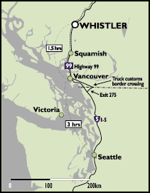
Whistler is about a four- to five-hour drive from Seattle, with the trip
to Vancouver taking about three hours, and the Vancouver-Whistler leg
about two hours, depending on road and traffic conditions.
 The
trip north from Seattle, along the Interstate 5 or I-5, to the
U.S.-Canada Douglas Border crossing (Peace Arch) is about 176 kilometers or 100 miles. Border crossing times vary according to the day and time,
with weekends seeing more line-ups.
The
trip north from Seattle, along the Interstate 5 or I-5, to the
U.S.-Canada Douglas Border crossing (Peace Arch) is about 176 kilometers or 100 miles. Border crossing times vary according to the day and time,
with weekends seeing more line-ups.
There are two ways to cross the
border. You can either go through the normal Blaine crossing or you can
go through the truck crossing.
Blaine
Crossing (aka the Douglas Border crossing)
Stay on I-5 and you will find
yourself right at the border crossing. After you make it through the
relentless interrogation, take the first exit on your right, and follow
that road east. Soon you will come to the Pacific Highway (aka 176th Street or Hwy 15).
Turn left on to the Pacific Highway and go north through Surrey, over the Cloverdale
Bypass to Hwy 1 (the Trans Canada Highway).
Truck
Crossing Alternate
During heavy peak traffic times
travelers can take the alternate Truck Border crossing by using Exit 275,
off of I-5, before getting to the main Douglas Border crossing. Often
times you'll come across a long line of trucks. If the line is all
trucks, try passing on the left. Once you're near the border, you
will find that the truck line is actually a different line than the
passenger car line, but they merge into one if the truck line is
long. The passenger car line goes off to the left while the truck
line goes to the right.
After you smile at the friendly border
guards and answer their questions (NO JOKES!), follow the Pacific Highway (also
known as 176th Street or Hwy 15) through Surrey, over the Cloverdale
Bypass to Hwy 1 (the Trans Canada Highway).
West to Vancouver
Exit onto Hwy. 1, traveling west, and follow the
highway out of Surrey, over the Port-Mann Bridge, through Port Coquitlam,
Burnaby and East Vancouver.
Hwy. 1 then travels over the Second Narrows
Bridge, through North and West Vancouver up to Horseshoe Bay, where
Whistler-bound drivers will exit right, onto Hwy. 99, also known as the
Sea to Sky Highway.
Once you pass Horseshoe Bay the trip to
Whistler is approximately 1.5 to 2 hours, depending on road conditions.
After you arrive in Whistler, continue on
through Function Junction and Creekside. Before you get to the main
village you will come across a three way intersection with a stop light.
This is Blueberry Drive. There is a tall wooden sign that also says
'Blueberry'. Turn left onto Blueberry Drive. Turn right onto Heron Place.
We are the last house on Heron Place.
3461 Heron Place
(604) 932 2475
Directions - Vancouver Airport to Whistler
Exit airport lot and continue straight on. Proceed over Arthur Laing Bridge,
then turn right with "Granville Street" exit.
Continue on Granville Street and onto the Granville Street Bridge. Stay in
right lane, taking the "Seymour Street" exit.
Continue on Seymour Street to Georgia Street - turn left.
Continue on Georgia Street through Stanley Park
Continue through Stanley Park and over the Lions Gate Bridge
Proceed over the Lions Gate Bridge, take the "West Vancouver" exit
onto Marine Drive. Follow Marine Drive to Taylor Way - turn right.
Continue on Taylor Way to Highway 99 North - exit left
Follow Highway 99 North to Whistler Village