| |
|
DISCUSSION
OF T-SHEET CONTENTS
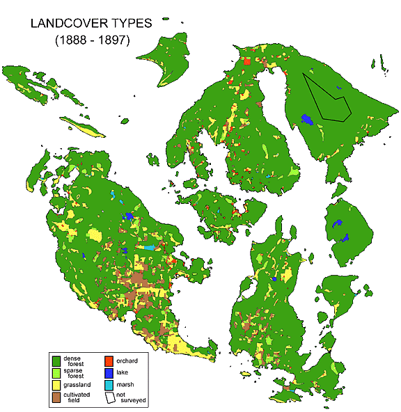
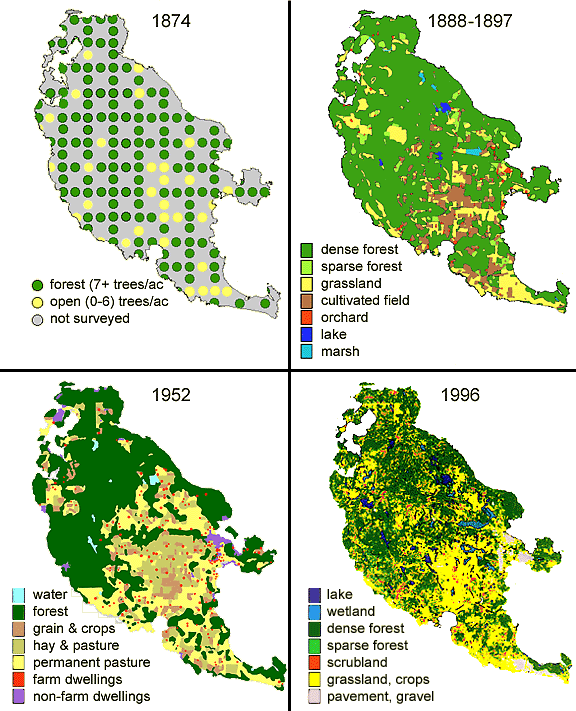
As portrayed
in Gilbert's elegant T-sheets and represented here in charts
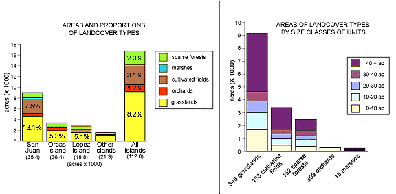
and a derived map, in the late 19th century 83% of the county's
total area of 112,000 acres, or 96,000 acres, was occupied by
dense forest. Another 2,100 acres were sparsely forested, either
because they naturally existed so (such as occurs on thin-soiled,
rocky highlands) or because patches of dense forest had been
cut or burned prior to mapping. Perhaps it goes without saying
that the depiction of forestland as "dense" does not
allow further inferences about the forest's actual composition
or condition. Since Gilbert's time most of the forests have been
cut and have subsequently regrown, but one may justifiably assume
that today's forests differ in character from those of the 1890s.
Some of the details of those differences are discussed in The
Presettlement Forest and Early Forest Composition
of this website.
Non-forested
open areas in Gilbert's T-sheets (17% of the total) were unevenly
distributed. Some islands were thoroughly forested, yet 25% of
San Juan Island was open, primarily due to grasslands. Throughout
the county grasslands accounted for 9,100 acres (8% of the total),
half of which were on San Juan. These areas would have been "natural"
grazing lands or livestock pastures that had never have been
plowed, and they undoubtedly represented the coastal prairies
and other savannahs as described by the earliest explorers, Hudson's
Bay Company employees, the U.S. Boundary Commission, and the
federal surveyors of 1874 .
Open land
categorized as cultivated fields had been plowed and were probably
sown with grains such as oats. A few of these fields had likely
been reclaimed for farming by draining pre-existing wetlands
but most were probably converted from natural, presettlement
prairies. The 182 plots and 3,355 acres under cultivation in
the T-sheets were primarily located in San Juan Valley and other
low-lying areas. Plowing in that era would have been accomplished
by small teams of draft animals, mainly horses.
Orchards that
produced apples, plums and pears for urban markets on the mainland
were extremely important to the early agricultural economy of
San Juan County, although most of them enjoyed only brief prosperity
(see Bigfoot's Forest in this website). Gilbert's T-sheets
recorded 309 separate orchards, nearly all of which were family
enterprises of less than 10 acres situated close to houses. The
magnitude of this early orchard industry can be understood with
a simple calculation; if fruit trees were planted 24 feet apart
throughout the 1341 acres of orchards countywide, the total number
of trees would have been about 100,000, which comports well with
the number of orchard trees documented for 1899 by N. S. Hayner
(Publ. Amer. Sociol. Soc., 1929, Vol. 23, pp 81-92).
Marshes or wetlands
constituted a minor landcover type that would have been recognized
and delineated by rushes, sedges and other diagnostic plants,
as well as shallow surface water. Altogether, 1,260 acres were
classified in this way and the majority were located on San Juan.
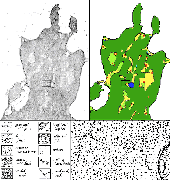
Besides landcover
features, Gilbert's T-sheets separately identified many human
developments, including fences, tracks and roads, trails, ditches,
residential houses, barns, farm outbuildings, schoolhouses, a
few rural churches, post offices, lime kilns, lighthouses, and
some commercial farms. Several fish traps projecting from the
south shore of Cattle Point extended for an aggregate total of
3.4 miles. Among details that were not depicted were dwellings
in towns of Friday Harbor and Eastsound and some hamlets. Nowhere
were land-ownership boundaries shown (T-sheets were not cadastral
maps). Gilbert documented landforms with 20-foot contour lines.
Based on notes that appear on twelve of the fifteen T-sheets
(three others failed to include such data), Gilbert claimed to
have recorded a total of 340 miles of shoreline and 193 miles
of roads and tracks in the San Juans.
In 471 instances
landowners were identified by name next to their houses, and
many other houses are indicated but lack names. These strictly
rural residences were usually situated close to cultivated fields,
orchards, and fenced grasslands. There were 162 named farmsteads
on San Juan, 147 on Orcas, 96 on Lopez, and 76 distributed on
other islands. The identifications were very thorough, if not
exhaustive, because the territorial census for the county in
1885 (before the T-sheets) showed a total population of 1,131
(including all members of families), and the U.S. Census of 1900
(after the T-sheets were completed) listed 686 families and a
population of 2,991. This amazing thoroughness displayed in the
T-sheets is another reason we should have confidence in other
portrayed details, such as the sizes of landcover units. In some
instances Gilbert labeled homesites as "deserted,"
by which Gilbert meant that "their owners find it necessary
to seek employment elsewhere in order to make a living,"
in other words the owners were temporarily absent at the time
of the survey (Descriptive Report for T-2231, 1895, p 9).
|
|
|
| |
|
APPENDICES
APPENDIX I. What is the form
of the original T-sheets and where may they be observed?
Each of the
fifteen original T-sheets depicts a different portion of the
county on a large sheet of paper or collodion-coated tracing
fabric measuring about 3 x 5 feet. In most cases two identical
copies exist, although all are manuscript versions, signifying
that they were executed by hand rather than by any mechanical
printing process. Landcover features were depicted in black ink
throughout, but contour lines on some copies were marked in red
ink. Half of the T-sheets were executed on coated linen and half
on very thick paper card. Each finished map contains a clear
title block that is signed by J.J. Gilbest, Ass't. The T-sheets
are stored at the National Archives and Records Administration
in College Park, Maryland, Cartographic Division, Research Group
23 and can be examined on-site upon request. Large-format photocopies
may be acquired for a fee.
The scale
of the T-sheets is 1:10,000, which means that one mile is represented
by 6.3 inches (1 inch = 833 feet). Thus, when all of the full-scale
T-sheets are fitted together, San Juan County occupies an area
of about 12 by 11 feet. On the other hand, details are so small
that individual cartographic symbols are about 1/16th of an inch
or less in size.
APPENDIX II. Can the T-sheets
be accessed online?
Digital versions
of the T-sheets of the San Juans may be viewed at http://www.wsulibs.wsu.edu/Holland/masc/xmaps.html
(follow the link: "San Juan Islands T-Sheet Index").
This site provides an index to the cartographic symbols. Some
exploration is required to zoom the T-sheets to their original
scale. If entire maps cannot be downloaded, screen images can
be captured using a "screen grab" tool.
APPENDIX III. Who was John J.
Gilbert and how did he execute the T-sheets?
Gilbert was
a lifelong employee of the U.S. Coast and Geodetic Survey (previously
called the Coast Survey until 1878 and known as the National
Geodetic Survey since 1970). He spent 22 years (late 1880s to
early 1900s) producing maps in the Georgia Straits region of
western Washington state. During that time his title was Assistant.
Judging by his work, Gilbert was a masterful surveyor and cartographer.
Notebooks in his lucid handwriting illustrate his qualities of
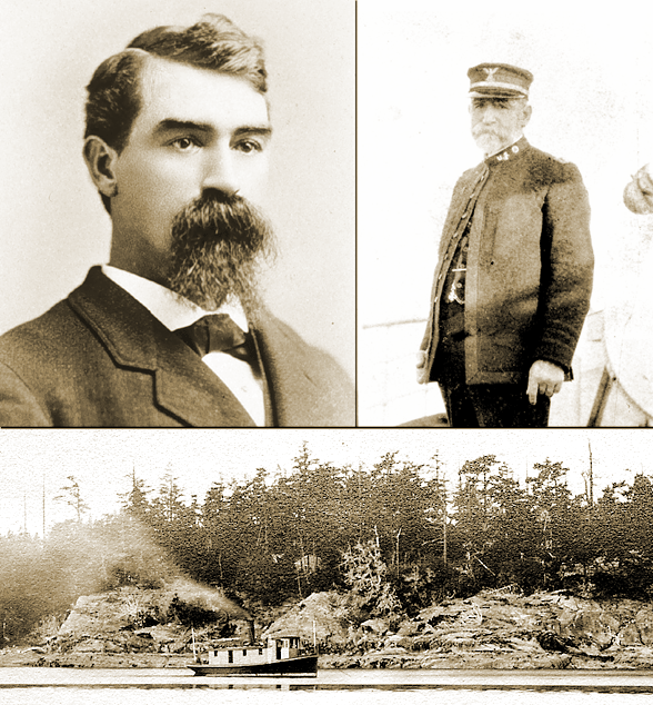
thoughtful observation and decisive accuracy. Photographs of
Gilbert portray a somber individual with prominent facial hair
(Figure 7). His official obituary upon his death in 1929, at
age 84, stated:
"His genial disposition
endeared him to all. The unparalleled record for continuous surveying
operations in one locality was held by Captain Gilbert.... His
original records are as current now as then.... Although some
of the modern-day methods and instruments were lacking, he was
able to produce substantially as accurate and thorough results
as are possible today."
(www.history.noaa.gov/cgsbios/biog6.html)
According
to a 1909 story in the New York Times, by which time he was the
agency's Inspector of Hydrography and Topography working in Washington,
D.C., Gilbert was reprimanded for on-going friction with his
boss, a man he had engaged in a workplace fistfight two years
before.
|
|
|
| |
|
Executing
a T-sheet of a coastal area required a land-based headquarters
for drafting, a launch and cutter for transport, a crew of supporting
assistants and equipment. Most details of the surveying process
and the number of helpers on Gilbert's team are not recorded.
When commencing work on an island, scores of triangulation stations
were established along its shore. Survey data were recorded by
plane table and the final product was completed at the headquarters
office, usually in the winter. Given limitations implicit in
line-of-sight surveying within densely forested landscapes, it
is not immediately evident how many of the nearly invisible inland
details were collected, let alone with such remarkable accuracy.
APPENDIX IV. What purpose did
the T-sheets serve?
The nation's
first scientific agency, the U.S. Coast Survey (later Coast and
Geodetic Survey) set a goal to produce detailed T-sheets for
the entire coastline of United States. It was an ambitious and
expensive project, and the T-sheets became the centralized and
standardized tools for understanding coastal resources and for
guiding development. In most cases the geographical coverage
in T-sheets was limited to precise delineations of the contours
of the coastline, the character of the immediate uplands, and
the locations of a few key landward features. In most locales,
T-sheets represent the earliest and most reliable geographical
records of coastal natural features.
Gilbert's
T-sheets always included landcover and landform details farther
inland, and as a result they have become valuable historical
documents. For mainland portions of Whatcom and Skagit Counties,
he studiously included about one half mile of inland landcover
and cultural features. However, for the islands of those counties,
and of course for the San Juans, his T-sheets thoroughly included
all landcover and cultural features right across the landscapes.
In the end,
T-sheets were never distributed or circulated through publication,
so they received little attention outside the bureaucracy of
the Coast and Geodetic Survey. Some of their information no doubt
filtered back to urbanizing centers and ports, before they were
simply filed away and basically forgotten. If, at the time they
were commissioned, the T-sheets of the San Juans were conceived
for some further specific purpose, it is not apparent today nor
has it ever materialized. Nowadays T-sheets of some sensitive
sites are being rediscovered as historical tools for projects
in ecological restoration, particularly of estuaries (Grossinger,
R. 2001. in The Historical Ecology Handbook, D. Egan and
E.A. Howell, eds. Island Press, Washington, pp 425-442).
APPENDIX V. How were San Juan
County's T-sheets rediscovered?
In the 1990s
this author (Tom Schroeder) began an amateur study of the forests
of San Juan County. From the beginning, a question arose: What
was the condition and distribution of the forests before Euro-American
settlement (or immediately following)? Very little reliable information
was initially available. The notes of the General Land Office
survey of 1874 (which themselves had to be retrieved from near-obscurity)
offered some insights (see Figure 7), but much remained unclear.
At first, I knew nothing of USC&G's T-sheets.
In late August
1999 a window into the county's landscape history serendipidously
opened for me. The 1999 San Juan County Fair organized a special
exhibit in a former poultry shed; the show featured mementos
of the county's maritime and fishing history. Alongside historical
photographs and diverse memorabilia exhibited by local fishers
and sailors, a framed photocopy of an old map featured Cattle
Point on San Juan Island; the map depicted several long fish
traps as they existed a century before, in the waters where the
map's current owner still gillnetted salmon. Although I was only
mildly interested in fishing history as such, the map caught
my eye because of the upland portions of the old map -- the land
was thoroughly filled in with cartographic symbols that denoted
grasslands, forests, roads, fencelines and dwellings. More landcover
details were crammed into that map than any other I had seen
for the San Juans, even including some aerial photographs of
a much later era. The map's hand-lettered title box indicated
a date of 1897, it credited the cartographer as J.J. Gilbert
of the U.S. Coast and Geodetic Survey, and it identified the
product -- now known as T-sheet #2301 -- as "Sheet No. 12,
Register No. 2301." These latter details signaled to me
that the framed map of Cattle Point was probably one of a larger
series. Did the others of the series illustrate additional portions
of the San Juans? If so, where were they located, and why had
they never been mentioned by local historians? From that moment
forward, I needed to find answers.
The owner
of the exhibited map knew nothing about its ultimate provenance
or the existence of additional maps. He had received the copy
as a gift from a fisher friend in San Francisco because it portrayed
the familar old fish traps off Cattle Point.
After several
communications I discovered that records of the Coast and Geodetic
Survey were stored at the National Archives and Records Administration
(NARA) in College Park, Maryland, and that the Cartographic Division
possesses several thousand original T-sheets from all around
the U.S., filed under Research Group 23. Fifteen of NARA's T-sheets
(plus copies) dealt with San Juan County, and "No. 12"
from the County Fair exhibit was among them. I then learned that
visitors could present themselves to NARA to view the maps but
that the agency was unable to provide and mail photocopies to
remote researchers. I also learned that the original T-sheets
were large in format and sometimes physically quite fragile.
I realized that a personal visit to NARA had to be considered.
In the spring
of 2000 an acquaintance who lived in Maryland (Cathy Lundmark)
agreed to visit NARA on my behalf as an associate investigator
to track down the T-sheets, to verify their geographical coverage
and condition, to obtain photocopies at full-scale and at half-scale,
and to mail them back to me. During this assignment Lundmark
maintained moment-by-moment contact with me by email and tenaciously
undertook these tasks, for which I am deeply grateful, thereby
unearthing and "repatriating" San Juan's T-sheets.
Only in 2001 and 2002 was I personally able to visit NARA to
investigate and collect additional materials related to Gilbert's
T-sheets.
APPENDIX VI. How were the T-sheets
posted online?
The unwieldy,
full-scale photocopies of the T-sheets were reserved for detailed
study. My original goal with the half-scale photocopies was to
reproduce sets of T-sheets, organized as atlases, for donation
to the three libraries in San Juan County, because the public
also deserved to see and study these remarkable documents. Unfortunately,
in the reduced versions details were only barely legible because
they were so minute at half-scale. Consequently, in April 2000
I abandoned plans to donate reduced, paper versions and embarked
on a project to post the fifteen T-sheets online in electronic
form at full scale. This required more technical proficiency
than I possessed. When I approached University of Washington's
Map Library with the T-sheet photocopies, the team of specialized
librarians enthusiastically endorsed my project to post them
electronically, and they agreed to scan the photocopies digitally.
However, some weeks later the UW librarians backtracked; UW map
librarians wanted to defer digitization for several months in
order to leverage the T-sheet project into a grander enterprise
to enhance their entire digital technology infrastructure, which
would have necessitated a long delay (to prepare a grant application,
allow time for grant review, set up a budget, purchase and shake
down new equipment, and realign library staff). So, in order
to keep the momentum for web-posting the T-sheets, I decided
to take my project and paper T-sheets elsewhere.
The Map Library
at Western Washington University in Bellingham made a point of
maintaining resources that related to the nearby San Juans. It
was staffed by a solitary, tireless, but overworked librarian
(Janet Collins); although she expressed immediate enthusiasm
for the project, her library had no facilities or experience
with large-format scanning. Nevertheless, Collins requested that
I entrust her with the full-scale T-sheets for a short time.
Astonishingly, within two days, she triumphantly announced that
the T-sheets had already been scanned at very high resolution
and recorded electronically as large CD files that preserved
all of the detail of the originals. As it happened, during the
intervening two days Collins discovered that WWU's Physical Plant
owned a large-format scanner that was used for architectural,
construction, and infrastructure renderings, and she single-handedly
negotiated the scanning of the T-sheet photocopies. Much can
be said in favor of personalized commitment to a project.
With the electronic
files of the T-sheets in hand, I again contacted the UW Map Library.
This time they agreed to compose the necessary meta data for
the finished files and, in a timely fashion, to arrange for web-posting
through Washington State University's server that accommodates
regional historical image databases. In turn, I provided a brief
webpage introduction. By midsummer 2000 Gilbert's T-sheets of
the San Juans were available for the entire world to view, one
hundred years after he had created them, thanks to a fruitful
three-university collaboration. The files may be viewed at http://www.wsulibs.wsu.edu/Holland/masc/sanjuanindex.html,
however extracting data from them is still inconvenient (follow
"View Map Image (Zoom))." Because the files utilize
the MrSid compression protocol, some perseverance is required
in order to discover how the images may be zoomed to full scale,
and, because of that format, after downloading they require specialized
software to be opened; alternatively, small zoomed fields may
be acquired by ordinary image-capturing tools (known as "screen
shots" or "screen grabs").
Subsequently
and independently, UW's ambitious Puget Sound River History Project
posted many additional regional T-sheets through WSU's server
(see http://riverhistory.ess.washington.edu/tsheets/framedex.htm).
Their additional T-sheets (however, not including the San Juans,
presumably because they lack rivers and estuaries) are readily
downloadable as medium-resolution TIF images; for San Juan County
T-sheets links are provided to the MrSid files at the website
mentioned in the preceding paragraph.
APPENDIX VII. Are there accessory materials associated with the
T-sheets?
A number of
incidental field notebooks at NARA were produced in association
with the T-sheets, but the most significant accessory materials
are handwritten Descriptive Reports that accompanied each completed
T-sheet as it was being registered by the Coast and Geodetic
Survey. These DRs contain remarks exclusively concerning coastal
features The fifteen DRs for the San Juans contain a total of
187 pages of text and 164 contemporaneous photographs! The Puget
Sound River History Project, cited above, has posted these records
online; the text is legible but the photographic images are obscured
because they were scanned as line drawings instead of halftones.
I have a digital collection of these images as halftones and
have used a couple of images in this web page and elsewhere in
this website (see Yellow Island Change).
APPENDIX VIII. How were data
from the T-sheets transformed into the derived map and bar charts
of the present webpage?
Landcover
units of the original T-sheets (identified by cartographic symbols)
were converted into the color-coded map of Figure 4 using low-tech
methods. That is, units in half-scale photocopies of T-sheets
were first colored according to type. Using a light table, outlines
of units were traced onto overlay sheets, which were then scanned
and saved as digital image files. Using Adobe Photoshop the fifteen
traced overlays were assembled and merged into a single image
showing all landcover units throughout San Juan County. With
the colored T-sheet photocopies as guides, each unit outline
in the digital image was filled with a color chosen to represent
that type.
Likewise,
the bar charts in Figure 5 were generated by the low-tech method
of cutouts and paper-weighing. Using the half-scale tracing sheets
mentioned above, a total of more than 1,200 landcover units were
manually cut out with scissors and segregated into a hierarchy
of piles: by island (4 piles) and by landcover types (7 piles).
A final hierarchical tier was generated as the size class
(0-10 acres, 10-20 acres, etc.) of each unit was determined by
visually comparing the cutout against a 1/8 inch grid (at a scale
of 1:20,000, which is that of the half-scale T-sheets, a 1/8
x 1/8 inch square represents almost exactly one acre). This created
five more piles. Altogether, 140 hierarchical piles resulted,
and the total area of each pile was determined by weighing it
on a highly sensitive electronic balance and comparing it against
the weight of a piece of paper of known area (acreage). Accordingly,
the aggregate areas of landcover units of each size class for
each island were compiled in a graphics program to construct
bar charts.
|
|
|


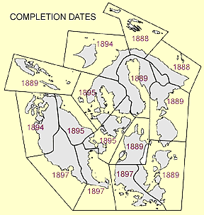 Figure 1. Coverage areas and completion
dates of the fifteen T-sheets. The prodigious cartographer J.J.
Gilbert produced the original manuscript T-sheets over the span
of a decade, during which he also mapped the shorelines of Whatcom
and Skagit Counties.
Figure 1. Coverage areas and completion
dates of the fifteen T-sheets. The prodigious cartographer J.J.
Gilbert produced the original manuscript T-sheets over the span
of a decade, during which he also mapped the shorelines of Whatcom
and Skagit Counties.