| |
|
GLO database
During
the westward expansion in the 19th century the U.S. General Land
Office was charged with documenting and describing frontier lands
as a precursor to homesteading and settlement. Across vast expanses
of landscape, survey crews systematically marked out the mile-square
grid of sections whose identities persist even today in landowners'
deeds. GLO surveys were expeditious and fairly accurate in establishing
section corners, but in secondary aspects they were superficial
(though not necessarily inaccurate). For example, summaries of
soil quality and vegetative landcover were "broad-brush"
or "coarse-grained;" that is, the assessments were
highly general but lacked specificity or detail. They were based
on the cursory impressions gained as the surveyors traversed
only the section perimeters (section lines), while ignoring
the vast interiors.
One
aspect of GLO surveys -- and a distinctively quantitative one
-- were their lists of witness trees. These trees helped to locate
and identify section corners and points halfway between section
corners, the so-called quarter-section points, all of which were
physically demarcated with short posts or rock mounds. The locations
of witness trees served as backups to pinpoint the monumented
reference points in case the they became disturbed. Witness trees
were systematically (that is, not randomly) selected: four for
each section corner (the nearest one in each compass quadrant)
and two for each quarter-section point (the nearest one on each
side of the section line). Accordingly, each mile-square section
contained eight of such witness trees; if additional trees were
intersected by section lines, they were added to the compendium
as "line trees." In modern parlance, witness trees
were "georeferenced" in the sense that their locations
were unambiguously identified with reference to fixed points
on the Earth's surface in terms of distance and compass bearing.
Witness trees were also identified according to species and diameter
at chest height.
Environmental
historians and geographers have extracted witness -tree data
(namely species, location and diameter) from early GLO surveys
as objective and quantitative evidence concerning early, pre-settlement
forests. The same approach is used in this article to characterize
the early forests in San Juan County, which were documented by
the GLO survey in 1874. Using those data, we can answer some
aspects of the question: What were the "original" forests
like when, or slightly before, settlers arrived?
The
1874 GLO Field Notes for San Juan County contain species, diameter
and location data for 2074 witness trees from all reaches of
the 172 square miles of land area. In the map that follows I
display the distributions of 1832 witness trees (line trees could
not be accommodated by the display method that I devised). For
the sake of contrast and comparison, I have prepared a similar
map that displays witness-tree species of an equivalent area
of a nearby mainland forest (northwest Whatcom County,) which
was surveyed piecemeal between 1859 and 1873. The latter database
contains 1642 witness trees, of which 1498 were used to construct
the map below.
Species maps
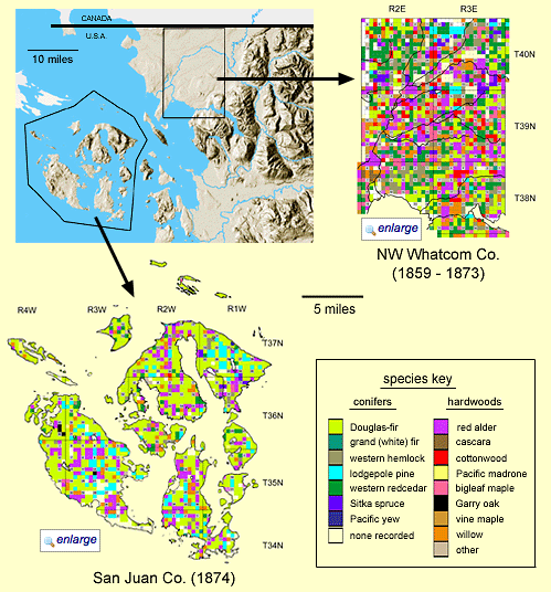
Even
at their small scale the above species distribution maps
point to some obvious patterns and geographical differences.
The principal colors in the San Juans are pale green (Douglas-firs),
light blue (lodgepole pines), and magenta (red alder), whereas
in NW Whatcom there are significant blocks of "reddish"
species (red alder, bigleaf maple and cottonwood). Although the
19th-century forest of NW Whatcom exhibited many Douglas-firs
(pale green) and western redcedars (dark green), they did not
generally occur in such large blocks as in the San Juans.
In general,
the same species of trees existed in both geographical areas,
although their proportionate representation and distribution
differed. The few exceptions of non-overlapping species were
all in the minor or "other" category and included:
Garry oak, juniper, and Pacific yew, which occurred exclusively
in the San Juans; and Pacific dogwood, beaked hazelnut, paper
birch, and vine maple, which were restricted to NW Whatcom. Minor
species common to both regions included Oregon ash, western cranapple,
and bitter cherry.
Notice
that each of the two regional maps can be enlarged for closer
examination.
Quantitative charts
Witness-tree
data lend themselves to quantitative analysis in addition to
distributional display. The following three charts compare tree
parameters species-by-species between the San Juans and Whatcom,
and for them the full data sets have been utilized (2074 and
1498 trees, respectively).
The
first chart (relative abundance aka frequency)
addresses the question, "What proportion of all trees was
represented by each species?" The second chart (average
tree diameter) documents reported tree diameters, as averaged
by species. The third chart (relative dominance) is derived
indirectly (see Appendix 2) from the data underlying the previous
two charts; dominance of a given species in a forest addresses
the question, "What proportion of a forest's total wood
volume is represented by each species?"
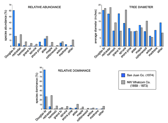
According
to the above chart of relative abundance Douglas-firs
were encountered in the San Juans in 1874 much more frequently
than any other species: above 60% of the time. Of all other species
in the San Juans, only alder rose above 10%, although shore pine
was also fairly abundant. In NW Whatcom, Douglas-fir, redcedar
and alder were roughly equal in abundance at 18-20% each, and
a much wider diversity of species was represented at intermediate
levels, except shore pine and madrone, and were proportionally
better represented there than in the San Juans.
When
average tree diameter is considered, most species in NW
Whatcom were equal in size or substantially larger than in the
San Juans, except for grand fir (and madrone, which did not occur).
To the ordinary observer tree diameter is often the parameter
that makes the strongest first impression of "tree size,"
but of course tree volume is a square function of diameter
(assuming a fixed height). That is, a tree that is twice the
diameter of another has a volume four times greater. Relatively
small diameter differences have large effects upon volume differences.
Stark
differences between the two regional forests show up in the chart
of relative dominance. In San Juan County Douglas-firs
accounted for the vast majority of "wood volume" (85%),
to such a degree that redcedar was the only other species whose
dominance rose above 4%. In other words, forests of the San Juans
in 1874 were compositionally nearly monocultures in which other
species were present but contributed very little volume. In contrast,
in NW Whatcom County top dominance was shared by Douglas-fir
and redcedar (25-30% each), and alder, hemlock, spruce, and maple
were also moderately represented. That is, Whatcom's early forests
were more diverse. It may be presumed that many of these distinctions
persist in today's forests.
Discussion: Ecological Perspectives
The
two geographical areas compared in this article differ in many
respects yet they are separated by less than 25 miles and share
overall climates, since they both lie within the Olympic rainshadow
that reduces precipitation and increases sunshine. The San Juans,
however, are largely rocky islands with shallow and poorly developed
soils; their valleys are composed of glacial drift, and there
are essentially no year-round streams. Most of NW Whatcom, in
contrast, is a low-lying flood plain of the Nooksack River and
its tributaries; its soils are alluvial and well hydrated.
The
most successful forest species in the San Juans, in 1874 as well
as currently, is the Douglas-fir. This tough species requires
direct sunlight, establishes well in rocky terrain, and does
not thrive in water-saturated conditions such as poorly drained
soils in winter or areas of high water table. Such wet areas
are more conducive to red alder, so long as direct sunlight is
present, which explains the presence of alder in the lowlands
of Lopez Island and in Crow and San Juan Valleys. Pacific madrone
and Garry oak are exclusively present in the San Juans because
they require dry soil in summer, which the Nooksack floodplain
cannot provide.
In
the Nooksack River valley sun-loving red alder, bigleaf maple,
black cottonwood and various other hardwood species prosper despite
the low summer rainfall because the soils are well watered by
the Nooksack. Redcedar and hemlock are similaly comfortable in
such a setting; they have the added advantage of being able to
germinate in the shade of hardwoods but eventually grow taller.
Lowland conditions are genereally too wet for Douglas-fir or
lodgepole pine, although these species grow vigorously on the
slightly elevated margins of the floodplain.
Overall,
differences in the early forests in the San Juans and Whatcom
illustrate that all forests in northwest Washington are not equivalent.
Species composition, distribution, and tree size are affected
by local differences in environmental conditions.
|
|
|
| |
|
Appendices
1. How the maps were constructed.
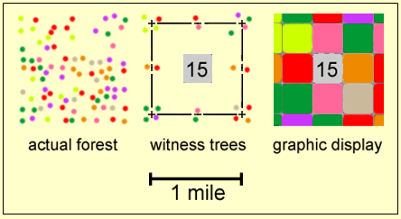
In
an actual forest (left), trees of various species (colored dots)
are scattered irregularly across the landscape. The GLO established
a gridwork of 1 x 1 mile sections, which were designated numerically;
they recorded witness trees exclusively around the perimeter
and ignored all internal one (center). Four trees (one per compass
quadrant) nearest to a section corner (+) were recorded as witness
trees, as were the two nearest trees astride the centerpoints
of each section line (+ and -). For the graphic display used
in this article, each section was subdivided by a 3-by-3 grid
whose nine areas were filled with species-coded colors representing
the section's eight witness trees and the section number (right).
This display method did not accommodate line trees, which occurred
irregularly with rrespect to the grid system.
2. How Relative Dominance
was calculated
A
species' relative dominance in a forest is a proxy value for
that species' contribution to wood volume. Ideally, it is a function
of abundance and tree volume. Strictly speaking, since GLO data
did not include tree height, tree volume is impossible to calculate.
However, the square of tree diameter (a function of trunk
cross-sectional area or basal area) offers an acceptable proxy
of volume. For the charts, the relative dominance of a species
was calculated as the proportion of that species' aggregate "volume"
(actually the aggregate of diameters squared in the present case)
relative to the forest's total "volume," expressed
as a percentage.
Therefore,
the relevant data bases from the GLO sources were processed as
follows: 1) a data base for each geographical region was constructed
for all trees and associated diameters; 2) data bases were sorted
by species; 3) each diameter was squared; 4) for each species
the squared diameters were summed; 5) these sums for all species
were also summed to obtain the forest "volume;" 6)
the proportion of the total forest "volume" of each
species' sum of squared diameters was expressed as a percentage;
7) charts were constructed from these values.
3. Sources
a.
Data for San Juan County. Copies of the GLO Field Notes for San
Juan County (1874) are available for reference at San Juan County
Department of Public Works in Friday Harbor. I photocopied this
lengthy document and entered all witness-tree data into a spreadsheet.
b.
Witness-tree data for NW Whatcom County was obtained indirectly.
Prof. David Wallin of Western Washington University generously
provided me with an electronic file of a spreadsheet of witness-tree
data for the six townships north of Bellingham, Washington. The
file had been prepared a few years earlier by two of his students,
but it contained some flaws: 1) when extracting tree-species
data from the GLO records (which are in longhand script), the
term "do." was consistently misinterpreted as
signifying Pacific dogwood, when in actuality it was the
19th-century way of writing "ditto;" 2) data from a
large block of T40N, R3E, Sections 4-9, 16-21 and 28-29 were
unaccountably missing; 3) some outdated species names such as
"balm" (for Balm of Gilead, otherwise known as black
cottonwood) and "balsam" (otherwise known as grand
or white fir) were treated as distinct species rather than pooled;
and 4) the species of forty one trees were left undeciphered
and formed a class of "unknowns."
For
the misinterpretation of "ditto" I noted that it exclusively
occurred after "fir" (otherwise known as Douglas-fir)
at section corners, where four witness trees were listed. Accordingly,
I interpreted the term "do." to signify Douglas-fir.
I
filled the missing data in the WWU spreadsheet by acquiring species
information from a copy of the GLO Field Notes. However, I neglected
the diameter data (at the time I only foresaw the species maps,
not the quantitative charts). As a result, out of the total database
for NW Whatcom of 1642 witness trees some lacked species identifications,
1498 of which were incorporated into the species distribution
map (including 185 without diameters as well as all "unknowns,"
whose species identities were temporarily assigned by their nearest
line tree, which otherwise could not have been utilized). The
Whatcom charts were constructed from 1457 witness trees whose
species and diameters were specified (including line trees, but
excluding all "unknowns").
For
this analysis, trees originally identified as "balm"
were combined with cottonwoods, and trees identified as
"balsam" were combined with grand firs.
|
|
|