| |
|
Section
1. PRE-SETTLEMENT LANDSCAPE
AND FORESTS (1792-1860)
(5 screens of text with
11 references)
TODAY'S
LANDSCAPE IN San Juan County, as most everywhere in the world,
is a product of both natural and human activities. Millennia
of aboriginal occupancy in the islands (which was seasonal) must
have affected the landcover, but the nature and extent of those
influences remains unknown. Later, it was Euro-American year-round
settlement with its accompanying ranching, farming and logging
that initiated the principal alterations in land use and land
cover that are with us today. This process started gradually
in the 1870s, accelerated through the peak in homesteading (around
1885-1890), and advanced with varying amounts of serious logging
(from 1890 to1930), the expansion of agriculture (1890 to 1950),
and residential in-filling (commencing in the late 20th century).
Even though tthe islands' underlying topography has changed little,
the land-covering vegetation has been altered considerably.
The
covering vegetation prior to settlement can be partially deciphered
from historical accounts, although these descriptive accounts
are limited. The early Spanish explorers and first traders left
no descriptions whatsoever; it was the British expeditions of
discovery that recorded the first really insightful observations.
The very first descritions were made during Capt. George Vancouver's
brief visit to the archipelago in 1792.
EARLY
IN THE evening of June 8, 1792 Vancouver's naturalist Archibald
Menzies joined Lt. Broughton in a small sailboat that probed
westward from the anchorage at Cypress Island toward Blakely
and Orcas Islands. These men had already formed preconceptions
about the landscapes of the broader region because they had recently
sailed across the top of the Olympic Peninsula, looped into Puget
Sound, and then cruised along Whidbey Island and recorded those
shorescapes for the first time. So, when they arrived in the
San Juan Islands, however, Menzies immediately recognized that
the archipelago was novel in terms of geomorphology and vegetation,
relative to what they had recently encountered:
"We could not help noticing
the great difference between these Islands & that fine Country
we had so lately examined [Whidbey
Island and low-lying lands south of Admiralty Inlet]. Here
[the San Juans] the land rose rugged & hilly to a
moderate height & was composd of massy solid Rocks coverd
with a thin layer of blackish mould which afforded nourishment
to a straddling forest of small stinted pines but I was not displeasd
at the change & general ruggedness of the surface of the
Country." (8, p. 51).
Vancouver seconded these observations
a few days later in his own journal:
"This country presented
a very different aspect from which we had been accustomed to
behold further south. Steep Rugged rocks little more than barren
rock, which in some places produced a little herbage of a dull
colour, with a few dull trees.
(12, p. 294). In proportion as we advanced to the northward,
the forest growth was less luxuriant." (12, p. 315).
On
June 18, 1892 Menzies re-entered the San Juans, this time to
approach Matia Island from the mainland coast near present day
Bellingham, and he again noted the conspicuous difference in
landscapes:
"Here the Shores were
rocky rugged & cliffy rising into hills of a moderate height
composing a numerous group of Islands thinly coverd with stinted
Pines, while the side we left in the Morning was fine sandy pebbly
beaches backed by an extensive tract of fine flat level country
coverd with a dense forest."
(8, p. 57).
"Straddling
forest," "a little herbage," and "thinly
coverd with stinted pines" are the earliest characterizations
of the forests of the San Juans. Not exactly superlative remarks
about our pre-settlement forests! Nearly two centuries would
pass before the distinctive forest growth in the San Juans would
begin to be understood as the combined result of thin soil underlain
with impervious hardpan or bedrock, of uncommonly diminished
rainfall especially in summer (when soil moisture is most needed
for plant growth), of exposure to turbulent windstorms, and of
centuries of occasional wildfires.
AFTER
VANCOUVER AND Menzies visited in 1792, a half century would pass
without further Euro-American contact. Then in 1853, soon after
moving its trading headquartes to Fort Victoria on Vancouver
Island, the British-licensed Hudson's Bay Company introduced
commercial flocks of sheep onto San Juan Island. The company's
objectives were three-fold: to exploit "prairie" forage
that was easily visible from Victoria, to suppress civilian settlement,
and also to stake a British land claim in the face of increasing
territorial pressure from U.S. pioneers. Wherever they injected
their commercial activities, Hudson's Bay Company agents diligently
recorded descriptions of the local landscape into their trading
journals.
Regarding
trading operations on San Juan Island, Hudson's Bay journal narratives
stressed their half dozen sheep stations and the daily doings
of the handful of employed ranch hands. The sheep stations were
all established on pre-existing open forage areas (variously
described as meadows, prairies, and grasslands), thereby confirming
that the islands were not thoroughly forested even in the mid-18th
Century, contrary to common misconceptions that the islands were
totally forested prior to settlement. (Other popular misconceptions
today are that the early forests were "uniform," "magnificent"
and "pristine.")
The
largest sheep station on San Juan was Bellevue or Home Prairie
overlooking present day Grandma's and Eagle Coves. It was described
as "about two miles long by half a mile wide."
(11, p. 137). Not far away, in the "basin" of the island
now called San Juan Valley, Oak Prairie extended over 1 1/2 square
miles (1000 acres); it was characterized by "groves of
oak scattered over it" (Garry oaks still occur on the
bordering rocky ridges). Oak Prairie was described as drained
by a semi-permanent stream (San Juan Creek flowing into False
Bay), and in low-lying places it collected standing water in
wet winters. (3, pp. 35-38; 5, p. 137). Within a few decades
settlers ditched this bottomland in order to reduce flooding,
to advance spring planting, and thus to facilitate summer grain
crops.
Farther
north, an open valley of significant size and "covered
with a luxuriant growth of grass" lay opposite Henry
Island where Mitchell Bay Road is today. (11, p. 137). On the
other side of the island, a few hundred acres of open land near
a protected bay was also used for grazing sheep; that bay would
soon be called Friday's Harbor, after the Hawaiian shepherd and
pioneer, Joe "Friday" Poalie, who was employed to manage
the station and who later settled on his own. (7). The exact
boundaries of Friday's open land are unknown today, but judging
by the pattern of early construction and in-town orchards, the
major part of modern Friday Harbor town, at least from First
Street inland, probably corresponds to his nearly-treeless grassland
(for an extended account of lanscape changes in that area see
"Lost & Found Prarie" in this website).
After tensions erupted over the
international boundary (the "Pig War"), Great Britain
and the U.S. established Boundary Commissions with technicians
assigned to reconnoiter the islands and to file professional
landscape decriptions of maritime, coastal and inland features.
Because civilian settlement was a low priority for the British,
its commission and the Royal Navy focussed on navigational features.
The Americans paid more attention to the land and hired local
guides to undertake overland expeditions from 1855 to 1860. The
U.S. findings (3, 5, 6) eventually appeared in federal publications
(4, 11).
Boundary Commission specialists
readily noted that the San Juan Islands formed a unified archipelago
with natural resources that were distinctive and diverse, although
ultimately limited in their "usefulness" (minerals,
building rock, surface water, exploitable wildlife, agricultural
potential, and timber). The 172 square miles of land area in
the San Juans were judged to comprise about 35% arable land (some
of which was timbered), 45% pasturage (also somewhat timbered),
and 20% forestland that was deemed unsuitable for either farming
or herding. The principal land cover was "forests consisting
of fir, pine, and cedar, which on some portion [note that
only "some"] of the islands attain great size and
beauty. The portion of open country is small patches of prairie
slopes, and mountain sides covered with luxuriant grass."
(11, p. 132). The area of untimbered open country is unstated
but probably amounted to about 5% or 5000 acres.
Several early observers took note
of the unusual combination of open areas and forest cover and
also detected that the latter itself was somehow odd, at least
relative to more spectacular timberlands elsewhere in Washington
Territory. One wrote, "the density of the timber is much
less than on the main land and open patches are seen."
(3, p. 38).
TIMBER
IN THE San Juans around 1860 was frequently described as damaged
and substandard compared to mainland timber, and these conditions
were customarily attributed to fire, although with little specific
justification. For example, in reference to San Juan Island,
"the lumber of the adjacent shores of Puget Sound is
superior to that of the island, the latter having all more or
less suffered from frequent conflagrations." (11, p.
137). As will be discussed presently, blaming the compromised
condition of the pre-settlement forests solely on fires may not
be justified. But first let us explore how forests of individual
islands were described in those early years, remembering that
the era was marked by a strongly utilitarian viewpoint.
Lopez Island was "generally
timbered but none of the timber here is large or dense enough
to offer much of an obstacle to clearing." (5, p. 30).
The timber was said to be "much injured by fire. There
are scarcely any trees of large size upon the island except in
a few low and swampy places." (11, p. 142). The island's
low topography was immediately appreciated for its agricultural
potential. "One-third of the area of this island, perhaps,
might be subjected to cultivation, but the greater part is still
covered with trees. Near the northern end tangled bushes and
fallen timber render it a difficult matter [for traveling].
Near its center is a prairie of nearly a square mile in extent
also a small one near its northerly extremity." (11,
p. 142).
Orcas
Island was also largely forested, but at least in some places
"the timber is not the best quality as the Indians and
white men too, in search of deer have, from time to time, fired
the forest, thus greatly injuring the growth of trees. Doubtless,
hereafter, when the more desirable lumber of other localities,
especially on the adjacent shores of Puget Sound, has been somewhat
exhausted, mills will be erected on these beautiful shores."
(11, p. 140). The dream of water-powered sawmills never materialized,
with the negligible exception of Newhall's small, late-19th C
operation. (N.B. The remark about white men setting fires requires
some comment, if only because Euro-Americans were so few at the
time. Who were the supposed perpetrators of these fires? The
original hand-written field notes that were later sanitized for
publication refers to "Indians and sometimes barbarians
of lighter hue." (6, p. 52). The well-connected American
author would have known that a deer-hunting party, including
Orcas trapper, fisherman, and patriarch Louis Cayou, had been
sent to Deer Harbor by Hudson's Bay Company a year earlier and
was still active seasonally. (9). The author's florid mode of
expression appears to reflect a specific chauvinistic animosity
toward the British as well as an alarmist cultural bias against
fires in forestland.)
On other parts of Orcas Island,
open or partially open land suitable for pasturage was evident
even though fire was not pointedly mentioned as the causal agent.
There were mountain slopes where "green grass is found
during every month of the year, and even almost to the very summit
of Mt. Constitution." (6 p. 52). In addition, open lowlands
were noted at the head of East Sound, where, "particularly
toward its northern end, are several beautiful spots of [potential]
agricultural land." Elsewhere, a "stream
of water, after traversing for several miles a beautiful valley
containing some very good meadow land, empties into Guerriere
Bay [i.e., West Sound] near its head." (11, p.
139). North-central Orcas was "all low land, heavily
timbered and in some places swampy." (6, p. 14).
In
a boosterist newspaper account of that early era (1869), the
landcover on Orcas was again described derisively: "The
timber is of a scrubby growth with little or no underbrush, and
is well adapted for sheep grazing. It is well supplied with water,
there being a lake and small ponds on the highest part."
(10).
The Boundary Commission reports
described the forests of Shaw Island as young and inferior, although
fire was not specifically mentioned as a causal factor. "The
timber, consisting of fir and cedar, is small and scattered.
Valleys are small and generally very swampy, and are rendered
almost impassable by thorny bushes everywhere heaped up in tangled
masses." (11, p. 150). Many such remarks about inundated
wetlands and streams derived from reconnaissances conducted in
late winter months when the ground water level was of course
high, soils were saturated, and temporary streams were running.
Significant seasonal variations were not yet much appreciated.
In earlier times small-diameter trees were dismissed as young
trees, whereas it is now appreciated (at least among discerning
observers) that small-diameter trees are a hallmark of poor growing
conditions in our forests.
Waldron
Island in the 1860s was recognized as having a low-lying western
half covered in forest except for a "small grassy prairie
containing about 100 acres" and a hilly eastern half
that contained "much good grass." (11, p. 138).
The forests of Blakely Island were described as "much
injured by frequent fires, and for this reason there are no inducements
for lumbermen." (11, p. 141); grass flourished on the
mountain slopes. On Decatur Island "there is much good
cedar timber, which growing in the low and moist lands, has escaped
the repeated fires which have swept through the forest."
(11, p. 141).
REPEATED REFERENCES TO fires in
descriptions of local forests from the mid-1800s are compelling,
but they require modern scrutiny. Early observers unthinkingly
attributed "reduced" forests to destruction by fires,
but they were insensitive to other, probable causal explanations.
It is now known by forest scientists that a wide assortment of
stressful environmental factors also reduce forest growth. In
the San Juans, for instance, the anomalous lack of rainfall and
the glacier-derived clayey soils conspire to produce destructive
extremes of soil moisture, that is too much in winter and too
little in summer for healthy forest growth.
One
hundred forty years ago (and persisting today in many circles)
the determining roles of geology and local climate for forest
growth were not well understood. However, in a moment of prescient
insight, George Davidson, who was later a celebrated coastal
surveyor and scientist, and who in 1855 visited the San Juans,
observed: "The soil is scarce and poor, and very dry
during the summer. The islands generally are covered with a thick
growth of Oregon pine [meaning the drought-resistant Douglas-fir],
other kinds of wood being exceptional." (4, p. 177).
His comments along this vein reveal that he connected reduced
forest growth with stressful environmental conditions.
TO
CONCLUDE THIS overview, the pre-settlement forests of San Juan
County were contemporaneosly described as stunted, sparse, and
damaged by fire. A few decades later at the dawn of settlement
the forests were described as highly varied and over-crowded
(see Section II). These early reports are historically invaluable,
yet they contain cultural biases and suppositions that are sometimes
hard to reconcile with modern views. For example, in historical
accounts fire is always portrayed as a regretable agent of unmitigated
forest destruction; the implied assumption was that, without
a long history of fires, local forests would have been much more
majestic than they actually were. Furthermore, early observers
occasionally expressed confidence that, once settlers arrived
to prevent fires, bountiful forests comparable to those of the
mainland would spring back and that a vibrant timber-cutting
industry would soon follow.
Such
optimistic expectations were (and remain) unrealistic, because
forest growth in the San Juans is intrinsically much reduced
and retaded compared to mainland forests. It is more appropriate
to realize that slow forest growth in the San Juans is governed
by inherent and unremitting ecological constraints. Furthermore,
in the absence of enlightened forest management and truly judicious
tree cutting, frequent and low-intensity underburning could have
actually benefited forest health and stocking density.
Sometimes such fires in pre-settlement times were aided by local
native people, but even then the practice was likely very limited
in scope and timing. Over millennia, however, wildfires surely
occurred and influenced our forests.
Despite many presumptions, direct
evidence of extensive prehistoric landscape fires in the San
Juan Islands is lacking. The early reports offer little or no
concrete evidence of forest-destroying fires, such as extensive
stands of severely blackened or fire-killed trees. In retrospect,
it seems possible that early Euro-American observers in many
cases confused evidence of intentional, low-intensity underburning
(i.e., not forest-destroying fires) by native people with the
specter of destructive, out-of-control, and high-intensity wildfires.
Even today many old stumps and trunks are somewhat charred by
fire, but these do not necessarily signify that forest fires
in times past were particularly intense or destructive; furthermore,
logged sites were formerly burned to reduce slash, so such remnant
signs of fire are more likely post- rather than pre-settlement.
On the other hand, it would be
inaccurate the deny that fires occurred. Recent study has detected
highly localized evidence of stand-replacing fires in a few places.
Severe but restricted fires did occur in parts of British Camp
on San Juan Island in 1715-1725 and around 1775 (9, p. 4). Major
fires also occurred on Yellow Island every several decades or
so (8), probably when more frequent and intentional low-intensity
burns associated with camas harvesting by native people escaped
control. The larger point here is that, inevitably, the actual
fire-return regime on any given site will remain uncertain and
imprecise without additional data, and until then early assertions
about fires in San Juan County should be interpreted with great
care.
Although
early reporters noticed "deficiencies" in the forests
of the San Juans, they probably missed the main contributing
factors because they lacked sophisticated ecological knowledge.
They could not have known that forest productivity in the archipelago
is inherently low, regardless of the fire regime, due to negatively
reinforcing limitations of soil fertility, poor winter drainage,
severe summer drought, shallow rooting depth, destructive winds,
and even aerosol sea-salt. Modern insights into the ecology of
forest growth and the consequences of various disturbance regimes
allow us to reconsider with somewhat greater clarity the conclusions
and perspectives of earlier commentators. Their unedited comments,
however, invite the imagination to dip backward into local environmental
history and to develop an open-minded quest for factual information
before leaping to unsubstantiated presumptions.
REFERENCES
1. Agee, James K. (1984). Historic
landscapes of San Juan Island National Historical Park. CPSU/UW
84-2. On file in San Juan Island National Historical Park, American
Camp Visitor's Center.
2. Agee, James K. and Peter Dunwiddie
(1984). Recent forest development on Yellow Island, San Juan
County, WA. Can. J. Bot. 62, 2074-2080.
3. Custer, Henry (1859). "Report
[to the U.S. Boundary Commission] of Henry Custer, Assistant,
of a reconnaissance of San Juan Island, and the Saturna Group.
April 11, 1859. On file in San Juan National Historical Park,
American Camp Visitor's Center.
4. Davidson, George (1855). Report
to the Superintendent, U.S. Coast and Geodetic Survey. Appendix
No. 26.
5. Gibbs, George (1859). "Report
of George Gibbs, Geologist, of a Geological Reconnaissance of
Islands of the Haro Archipelago." Transcription of original
in National Archives in San Juan Island National Historical Park,
American Camp Visitor's Center.
6. Kennerly, C.B.R. (1860). "Report
[to the U.S. Boundary Commission] of Dr. C.B.R. Kennerly, Surgeon
and Naturalist, of a reconnaissance of San Juan Island, and the
Saturna Group. April 11, 1859." On file in San Juan Island
National Historical Park, American Camp Visitor's Center.
7. Koppel, T. (1995) Kanaka:
The Untold Story of the Hawaiian Pioneers in British Columbia
and the Pacific Northwest.Whitecap Books, Vancouver, B.C.
8. Menzies, Archibald (1792).
Menzies' Journal of Vancouver's Voyage. Edited by C.F. Newcombe.
Provincial Archives of British Columbia. 5 (1923).
9. Richardson, David (1971).
Pig War Islands: The San Juans of Northwest Washington. Orcas
Publishing Co., Eastsound, WA
10. Territorial Republican, May
17, 1869, p. 1.
11. U.S. Congress (1867). "The
Island of San Juan." Executive Document No. 29. Senate,
40th Congress, 2nd Session. Report of the Secretary of State.
Washington, DC.
12. Vancouver, George (1798).
Voyage of Discovery to the North Pacific Ocean and Round the
World (1790-1796). Reprinted 1967, Da Capo Press, NY. Vol. 1.
Section 2: DESCRIPTIONS FROM THE DAWN
OF SETTLEMENT - 1874
(9 screens
of text)
The
first thorough survey in San Juan County was conducted by the
federal General Land Office (today's Bureau of Land Management)
in the autumn of 1874, which was a mere two years after the international
boundary was resolved and before any significant settlement.
Though by no means free from surveying errors, the 1874 GLO survey
identified all townships and sections (36 and 1 square miles,
respectively). The GLO surveyed section and township lines (1
and 6 miles apart, respectively), monumented section corners,
measured and recorded witness trees, and commented upon the character
and "useful" potential of the land and its vegetation
cover.
T.M.
Reed, J.T. Sheets and J.M. Whitworth were the contract surveyors
who produced the 1874 GLO survey of the San Juans. After surveying
a township, these professional s described its landscape in brief
narrative form. Conforming
to the utilitarian directives underlying the rectangular survey,
the surveyors summarized each township in terms of agricultural
and pastoral potential, and exploitable timber and mineral resources.
Upland forestland in the San Juans is most often described as
range land suitable for pasturing sheep and goats, which indicates
a certain openness, as compared to dense forest.
References
to the islands' forests are brief and rarely complimentary. The
most frequently repeated terms are "young fir thicket"
and "thicket of young pine and fir." "Open
timber" is rarely mentioned, and hardly ever did the
surveyors gush with enthusiasm. The descriptive narratives were necessarily
quite superficial but they do reveal an attempt at accuracy and
objectivity. The surveyors measured, pinpointed and identified
more than 2000 witness trees in the GLO survey, and those data
are presented, in part, in Section 3 of this chapter.
The
GLO field notes of 1874 confirm the existence of numerous lowland
open areas within a generally forested matrix. By that date pre-existing
openings were already largely claimed by settling farmers and
were fenced; the settlers did not create such clearings by actively
cutting away the forest, they were already in existence. Many
of the openings were identified as "swamps" or other
wetlands but others were cited as prairies, pastures or fields.
Some of these areas coincided with low areas and others were
on bench lands and hillsides. Between the 1860s and 1874 limited
settlement was becoming evident, but time of occupancy was brief
and the population was still very small (there were only 93 men
in the entire county in 1870). So few Euro-Americans would not
have produced profound changes upon the forested landscape by
1874, when the GLO survey wrote their desciptions, especially
since the settlers were primarily preoccupied with farming and
ranching the pre-existing openings, rather than logging (an arduous
activity that had not yet acquired any commercial reward). Although
small-scale tree cutting had begun in order to produce such items
as locally used fuel wood, fence rails, shakes, and poles, no
appreciable logging had yet begun.The GLO survey of 1874 thus
predates logging in the San Juans by about 20 years, and therefore
the following
passages are impressions of the pre-settlement land-cover conditions
in the San Juans before much had been changed as a result of
settlement.
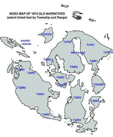
ORCAS ISLAND
Township 37 North, Range 1 West (NE Orcas Island)
"This
township may be said to be chiefly the top, sides and base of
Mt. Constitution, which is 2400 ft. in height. There are many
settlers living along the beach and good gardens and nurseries,
the fruit being very fine.
The whole township affords excellent
pasture for sheep, of which there are many.
There is a limestone quarry on
the island just west of this Township which has been in operation
many years, and affords excellent lime. There are also doubtless
other quarries of the same kind in this Township, not lying on
the water."
J.T. Sheets, Sept. 30, 1874. GLO Field Notes, p. 218.
Township 37 North, Range 1 East (Pt. Lawrence,
Orcas Island)
"This
small fractional Township on the extreme Eastern end of Orcas
Island is rocky & fit only for sheep pasture, for which it
is used."
J.T. Sheets, Sept. 30, 1874. GLO Field Notes, p. 218.
9th Standard Parallel through Ranges 2 & 3
West
"Orcas
Island, through which this standard runs, is high & mountainous,
but has many good claims & settlers. The hills afford excellent pasture
for sheep, of which there are many on the Island." J.T.
Sheets, Aug. 31, 1874. GLO Field Notes, p. 240.
Township 36 North, Range 1 West (Olga and Doebay,
Orcas Island)
"This
township is hilly & mountainous but contains some pieces
of first rate land & Six or Seven settlers. The hill land
is good for sheep of which there are many on the island." J.T. Sheets, Sept.
5, 1874. GLO Field Notes, p. 257.
Township 36 North, Range 2 West (Orcas and Deer
Harbor, Orcas Island)
"This
township, like the west of the Island, is hilly & rocky but
there are many good claims and the Island is especially adapted
for sheep."
J.T. Sheets, Sept. 15, 1874. GLO Field Notes, p. 271.
Township 37 North, Range 2 West (NW Orcas Island)
"This
Township is less mountainous and contains more settlers than
any other [of
the] island. West of what is known as Buck Bay [East Sound]
are several fine farms and on the East side of Buck Bay is
a lime stone quarry which affords excellent lime." J.T.
Sheets, Oct. 10, 1874. GLO Field Notes, p. 321.
Township 36 North, Range 3 West (SW Orcas Island)
"This
fractional Township is a high tongue of land affording a pasture
for stock but with little arable land. There are many sheep on
it & this is its only value." J.T. Sheets, Oct., 12, 1874. GLO Field
Notes, p. 327.
SAN JUAN ISLAND
Township 34 North, Range 3 West (S. San Juan Island)
"The
larger part of this Township is prairie land of which the soil
is sandy & of very good quality.
Scattered over the prairie are
small groves of alder, willow and pine.
The northern part of the township is timbered with fir, pine,
alder & willow. The land is all claimed by settlers &
the U.S. Garrison, which is situated in Sec. 2 & 11.
San Juan Village is situated in
Sec. 1 on the shores of Griffin Bay. It is composed of about
a dozen houses among which is a large store, also a hotel. In
the southern part of sec. 12 there is a large spring of fine
fresh water affording a full supply, during all seasons of the
year."
J.M. Whitworth, Aug. 28, 1874. GLO Field Notes, p. 48.
Township 35 North, Range 3 West (Central San Juan
Island)
"A
fair proportion of this Tp. is good agricultural land situated
principally in a bed or valley running N. & S. through the
Township.
The land is for the most part claimed
& already occupied, having been converted into valuable &
thrifty appearing farms. The Western & Northwestern part
of the Tp. is high, broken & mountainous, the balance is
rolling & more or less hilly.
The timber is chiefly fir &
in the low lands alder of moderate size growth. The fir is pretty
equally distributed excepting of course on the parts noted as
prairie.
The settlers besides farming to
a moderate extent are engaged in sheep raising for which the
high lands are admirably adapted.
The coast lines lying in this Township
are usually rocky & rough." T.M. Reed, Oct. 20, 1874. GLO Field
Notes, p. 80.
Township 35 North, Range 4 West (W-central San
Juan Island)
[The summary for this township
is missing from the record. However, the GLO field notes contain
more localized summaries for each mile-long section boundary.
These substitute summaries are reproduced below; "E of
14" signifies the eastern boundary of section 14 in
T35NR3W (which is also W of 13, of course). Due to the shoreline,
portions of only 10 sections are included in this township.]
N of 1: Land fair in quality, good for farming purposes.
Soil 1st rate. Timber fir & alder.
E of 2: Land passes through open timber & heavy
growth of fern most of the way. Soil good in bottom1st rate.
N of 2: Soil 2nd rate, land rolling, densely covered
with small firs & pines.
E of 3: Shoreline bold & rocky. Land broken
& rough. Soil 2nd rate, thick brush fir and alder.
N of 3: [No summary.]
E of 11: This line passes over fine body of alder
land much better than average. Soil 1st rate. Timber mostly alder
& fir.
N of 11: Land generally of fair quality some 1st
rate but covered with dense growth of small fir, alder, willow
& briar.
E of 12: Land very broken. Some scattering large
fir timber, underbrush small fir, tasselwood & generally
very dense. Soil 2nd rate.
N of 12: Land generally good on West half of line.
Bottom land 1st rate. Timber alder & fir.
E of 13: Land mountainous rough and rugged in places
bare & rocky. Soil 3rd rate. Except in alder bottom, which
is first class. Timber fir & alder. Underbrush same.
N of 13: Land broken. Soil variable in swale &
bottom 1st rate, balance 3rd rate. Timber fir & alder. Underbrush
same & very dense.
E of 14: Land rough & rocky. Soil 2nd rate.
Timber fir, cedar, alder & pine. Underbrush, same with gooseberry
& rosebriars.
N of 14: Soil 3rd rate. Land very broken. Timber
fir & alder. Underbrush the same.
E of 23: Land rough & rocky over beds or ledges
of limestone. 3rd rate soil. Timber principally fir scattering
underbrush same.
N of 23: [No summary.]
N of 24: Land very broken & mountainous. Soil
light, second rate. Timber mostly fir, some willow & alder.
E of 24: Land hilly & generally rocky. Soil
2nd rate, good grazing for sheep.
E of 24: This line passes over little land for
cultivation: a small tract around Trout lake being the only soil
cultivable. The remainder is rocky & mountainous also brushy.
Numerous herds of sheep & goats roam & inhabit these
mountain wilds.
E of 25: Land steep mountainside descending
from Mt. Dallas, mostly rough & rocky. Soil 2nd rate. The
shore line bold and rocky.
N of 25: Line runs over southern slope of Mt. Dallas.
Land rocky. Soil 2nd rate. T.M. Reed, Sept. 24-26, 1874,
GLO Field Notes, pp.148-154.
Township 36 North, Range 3 West (NE San Juan Island)
"Relating
principally to that part of the Township situated on San Juan
Island as the other small islands have been described in order.
The quality of the land in this township is considerable below
the common average. There is a small portion of good rich agricultural
land situated in small detached swamps and alder bottoms of moderate
extent. The uplands are generally rolling and quite rocky and
in the southern part of the township very much broken. They are
well adapted for ranges for sheep and goats.
The shorelines of San Juan and
Spieden channels and of Rocky Bay are very rocky and rough. The
rock is chiefly of a metamorphic nature. The lime stone ledges
that that have been noted are small and rather impure.
Timber is chiefly fir and near
the north end of San Juan Island cedar of fine quality."
J.M.
Whitlock, Sep. 28, 1874. GLO Field Notes, p. 130.
Township 36 North, Range 4 West (San Juan, Henry
and Pearl Islands)
"The
quality of the land over which the foregoing surveys have extended
will average about 2nd rate, much of it is very broken and rocky,
the cultivatable land being confined to the valleys which are
small and narrow. Timber principally fir and alder." T.M. Reed, Oct. 15,
1874. GLO Field Notes, p. 174.
LOPEZ ISLAND
Township 35
North, Range 2 West (N. Lopez Island and Pear Pt./Turn Pt., San
Juan Island)
"The
quality of the land in this Township, particularly on Lopez island,
is considerably above the common average. There is upon that
Island a large proportion of rich bottom land covered with fern
& alder. A large portion of this land still remains unclaimed.
The choicest parts, however, are already occupied by settlers
& in some instances, have been converted into valuable &
thriving farms. The uplands are generally rolling 2nd & 3rd
rate land, chiefly adapted for stock range.
Timber chiefly fir, cedar, alder
& willow. The cedar occurs principally near the northern
part of the island, the other varieties are pretty equally distributed." J.M. Whitworth, Nov.
20, 1874. GLO Field Notes, p. 118.
Township 34 North, Range 2 West (SW Lopez Island)
"A
fair proportion of the land in this Tp. is fern & alder bottom
& is of a good rich nature, well adapted for agricultural
purposes. The greater part of this land is already claimed. The
uplands are generally rocky & rolling, valuable only for
grazing purposes. The timber is chiefly fir with some alder,
cedar, spruce & laurel which is equally distributed. The
coast of that part of the island embraced in this Tp. is generally
rocky & broken." J.M. Whitworth, Nov. 2, 1874. GLO Field Notes,
p. 97.
SHAW ISLAND
Township 35
North, Range 2 West (S. Shaw Island)
"The
land in this Township is generally second rate soil with small
pieces of good land. It is best fitted for sheep pasture." J.T. Sheets, Nov. 1,
1874. GLO Field Notes, p. 223.
Township 36
North, Range 2 West (Shaw Island)
"This
Township comprises the greater portion of Shaws Island. There
are some twelve settlers on the Island which contains sufficient
land for small farms, but the larger portion is only fit for
sheep pasture." J.T. Sheets, Oct. 30, 1874. GLO Field Notes, p.
307.
WALDRON ISLAND
Township 37North, Ranges
2/3 West
"The
quality of land in fractional Secs. 11, 14, 15 and West 1/2 of
12 is 1st rate, and all the settlers are located on the above
named sections.
The
balance of the Island is broken, hilly and covered with a dense
growth of timber, and undergrowth and is unfit for cultivation." J.T. Sheets, April 18, 1878. GLO Field Notes, p.
232.
BLAKELY ISLAND
Townships
35/36 North, Range 1 West (Blakely Island)
"This
island is high, rough & mountainous and contains but a small
proportion of land suitable for farming. There are two settlers
on the island making considerable improvements and other pretensions
toward farming. Two fine small lakes occur in the central portion
of the Island around which are small tracts of good arable lands.
Some fine bodies of good timber are found in various portions
of the Island. The island is generally thickly overgrown with
young fir and cedar. Deer & quail abound." T.M. Reed, Oct. 2, 1875.
GLO Field Notes, p. 282.
DECATUR ISLAND
Township 35
North, Range 1 West (Decatur Island)
"Decatur
Island contains a very considerable portion of good agricultural
land at least two thirds being very productive, although then
northern part is somewhat mountainous & broken. Several fine
claims have been made, particular mention of which might be made
of John Read's claim. Secs. 21 & 28 - an old settler who
now has a farm in good state of cultivation. The timber on this
island is quite valuable, especially the cedar which is particularly
adapted to making of shingles. Deer abound on this Island." T.M. Reed, Oct. 11,
1875. GLO Field Notes, p. 290.
SMALLER ISLANDS
Township 35
North, Range 1 West (James Island)
"James
Island is very high for its size and quite open, covered with
good grass but so rocky as to be unfit for cultivation. Mr. Ed
Heland has upwards of 200 sheep on the island." T.M. Reed, Oct.
13, 1875. GLO Field Notes, p. 292.
Township 35
North, Range 1 West (Center &Trump Island)
"Trump
Island is quite high and bluffy, unfit for cultivation but very
good for sheep grazing.
Center Island is low, contains
a considerable quantity of good agricultural land. Timber 1st
quality."
T.M. Reed, Oct. 7, 1875. GLO Field Notes, p. 294.
Township 35
North, Range 1 West (Frost Island)
"This
Island has a rocky & rough shore but in the interior quite
level. It is unfit for cultivation although it is covered with
a very fine growth of grass affording an excellent sheep range.
Several deer was [sic]
seen on this Island." T.M. Reed, Oct. 9, 1875. GLO
Field Notes, p. 296.
Township 36North,
Range 4 West (Guss Island)
"The
quality of land on this island is of first rate, the underbrush
and timber has all been cleared off and the island is cultivated
for garden purposes, on which large quantities of vegetables
are raised."
J.T. Sheets, June 12, 1878. GLO Field Notes, p. 324.
Township 36
North, Range 3 West (Cliff aka Brush Island)
"Cliff
Island, containing 13.8 acres, is an island with rocky shores,
and rises to a height of about 70' above the water. There are
seven or eight acres of good land, and the island is mostly covered
with brush and scrub timber. There are fir, willow, cedar, pine,
madrona, red cedar, yew, white fir, maple & juniper trees.
The undergrowth consists of snow-drop bush, soap berry, salal,
hardhack, rose, wild pea, wild currant, spotted brown lily, Indian
paint brush, moss and fern." H.L. Coffin, March 29, 1928. GLO Field
Notes, p. 332.
Township 36
North, Range 2 West (Bell Island)
"Bell
Island, containing 3.5 acres, is a rocky island about 60' high.
The shore line is a rocky bluff which drops down about 6' above
water at the southeastern end. It is covered with scattering,
scrubby timber of fir, pine, red cedar, madrona, small juniper
and scrub oak. The undergrowth is hardhack, snowdrop bush, wild
honeysuckle, Indian Paint Brush, blue gentian, licorice fern,
buttercup, wild pea, gooseberry, wild currant and some grass.
The soil is good, but scant." H.L. Coffin, April 8, 1928. GLO Field
Notes, p. 334.
Township 36
North, Range 2 West (Sheep aka Picnic Island)
"Sheep
Island is a small, low island in West Sound Bay lying only a
short distance from West Sound dock, in a southeasterly direction.
It is about 15' above the water. It has some fairly good soil,
and has about three dozen scrubby trees. They are fir, cedar,
maple and small juniper. There is very little underbrush, of
rose, snowdrop bush; and some grass." H.L. Coffin, March 30, 1928. GLO Field
Notes, p. 335.
Township 36
North, Range 2 West (Double Island)
"Double
Island is situated in the West side of West Sound Bay, Orcas
Island, San Juan County, Washington, about 400' from the Orcas
Island shore. It is really two islands separated by a narrow
channel which goes nearly dry at extreme low water.
The larger island which contain
16.86 acres, rises about 50' above high water, and has a bald,
rocky shore line all around with the exception of two or three
small, rocky beaches. There are about six acres of good land,
the balance being rocky and very poor.
It is fairly well covered with
brush and scrubby timber, but there is no merchantable timber
of any kind. The timber consists of fir, cedar, madrona, willow,
red cedar, wild cherry and small, scrub oak. The undergrowth
consists of wild honeysuckle, hardhack, wild rose, salal, snowdrop
bush, wild currant, Indian Paint brush, common fern and some
grass.
There is a hut built of small poles,
8 x 16 in size, with walls about 5 feet high, dirt floor, erected
within the last two years - about 150' from the south end of
the island. There is also a small plank structure, comprising
a bin, with a platform and small piece of roof, at the northwest
side of the island where some person has been sorting or sacking
broken clam shells. These two structures have absolutely no value
as improvements.
The smaller island, with an area
of 4.24 acres, also rises to a height of about 50' above high
water. It is a rocky island and has no agricultural land on it.
The timber is much like that of the larger island, but no merchantable
timber of any kind. Its only value lies in its wild and picturesque
beauty."
H.L. Coffin, June 11, 1928. GLO Field Notes, p. 338.
Township 38
North, Range 2 West (Sucia Islands)
No summary. F.G.
Betts, 1924-5. GLO Field Notes, p. 18.
Township 36
North, Range 3 West (Spieden Island)
"The
shore of this island, with slight exceptions noted are solid
rock on the southern shore, the rock is slightly stratified sand
stone dipping at an angle of about 400 to then south. The eastern
and northern shore are composed chiefly of a coarse conglomerate
rock.
The Island itself is a high ridge
with steeply sloping sides. Except the eastern extremity, which
is comparatively low rolling prairie. The southern slope of the
Island is bald through its entire length whilst the northern
slope is thickly timbered with fir, cedar & laurel with dense
undergrowth of fir, scotch plum and salal. The island is chiefly
valuable for a sheep and goat range." J.M. Whitworth, Sept. 26, 1874. GLO
Field Notes, p. 129.
Township 36
North, Range 3 West (Flat Top Island)
"This
Island is composed of stratified sand stone underlain by a much
harder rock having the appearance of metamorphic rock with here
and there small showings of limestone rock. The sandstone strata
dip south at a slight angle. The southern slope of this island
is bald while the northern slope of this island is covered with
fir timber with undergrowth of fir, scotch plum, salal and willow.
A flock of rams were [sic] seen upon this Island." J.M. Whitworth, Sept.
28, 1874. GLO Field Notes, p. 130.
Township 34
North, Range 2 West (Long Island)
"This
island is chiefly prairie with a strip of fir timber along its
northern shore. It is claimed by Jones. Its shores are rocky
& rough." J.M. Whitworth, Nov. 2, 1874. GLO Field Notes,
p. 95.
Township 35
North, Range 2 West (Turn Island)
"The
island is rough & rocky. Timber fir, cedar & juniper.
Undergrowth fir, soap berry, scotch plum & salal." J.M. Whitworth, Nov
19, 1874. GLO Field Notes, p. 115.
Township 37
North, Range 4 West (Cemetery and George Islands)
"These
islands are rocky. The former contains a grove of fir, juniper
& laurel trees; the latter is treeless, is used by Indians
for burial grounds." J.M.Whitworth, Oct. 9, 1874. GLO Field Notes,
p. 144.
Township 37
North, Range 4 West (Johns Island)
"A
large portion of this island is good agricultural land. The island
is comparatively low with gently rolling surface. Timber fir,
laurel, alder, cottonwood & juniper. Timber is generally
open, its southern coast is beautiful gravelly beach; its northern
& eastern & western shores are very rocky & rough.
The rock is sandstone of hard quality." [This island is] at
present ranged over by the sheep of Mr. John Todd. J.M. Whitworth,
Sept. 30, 1874. GLO Field Notes, p. 147.
Township 37
North, Range 4 West (Stuart Island)
"The
surface of this island is very much broken & mountainous
with the exception of a small alder & maple bottom in sections
20 and 21. The land is generally worthless except for stock range.
Timber fir, cedar, alder, maple & laurel of moderate sized
growth. The entire coast is very rocky & rough and is composed
of sandstone some of which on western shore is of beautiful quality.
[This
island is] at present ranged over by the sheep of Mr. John
Todd." J.M. Whitworth, Oct. 13, 1874. GLO Field Notes,
p. 147.
Township 37
North, Range 4 West (James aka Satellite Island)
"Is
suitable only for sheep or stock ranges. The land is rocky &
rolling and on Northern shore very high. [This island is] at present ranged
over by the sheep of Mr. John Todd." J.M. Whitworth,
Oct. 5, 1874. GLO Field Notes, p. 147.
Township 36
North, Range 4 West (Sentinel Island)
"Sentinel
Island is high & rocky, is covered with fir timber, with
undergrowth of fir, pine, scotch plum and salal." T.M. Reed, Sept. 28,
1874. GLO Field Notes, p. 176.
Township 36
North, Range 4 West (Small and Cactus Islands
"These
Islands are low and rocky, are composed of a firm quality of
stratified sandstone. Timber open. There are principally fir
with few laurel. Undergrowth same & scotch plum." T.M. Reed, Sept. 28,
1874. GLO Field Notes, p. 177.
Township 36
North, Range 2 West (Crane Island)
"The
shores of the Island are very rocky & broken. Timber fir,
cedar, alder, laurel, and underbrush. Some level land in center
of island. Land second rate, fir scrubby. Island not enhanced
in value by location near to any town or village, Friday Harbor
being the nearest village of about 30 inhabitants about 6 miles
distant. Walter Cadwell has a log house on the northeastern end
of the Island with about 1/4 of an acre fenced in around the
house and about 4 acres an 1/8 of a mile Southwest of the house
in cultivation. Value of improvements about three hundred dollars." E. Vongohren,
March 7, 1884. GLO Field Notes, p. 244.
Reference.
General Land Office (1874). "Surveyor's
Field Notes of San Juan County, Washington." Typed transcript
(c. 1970), Dept. of Public Works, San Juan County. Friday Harbor,
WA. Manuscript versions with different pagination are also available
at Public Works and Bureau of Land Management offices in Portland,
OR and Washington, DC.
Section
3. FOREST QUANTITATION
- 1874 vs 1990
(3 screens of text with
3 charts)
For
a variety of reasons, forests ineluctably change with the passage
of time. Some processes of change are natural: growth, crowding,
windthrow, disease, succession. Other processes are more clearly
caused by people: tree cutting, root excavation, soil compaction,
species rearrangement. Still other agents of change, such as
grazing of saplings and brush by livestock and burning initiated
by people, lie somewhere between the purely natural and the purely
anthropogenic because complex disturbances such as fire and grazers
can be so unpredictable and the changes so unintended.
A
quantitative comparison of tree species, sizes, numbers, and
density at two points in time offers a certain insight into forests,
but it devalues (by ignoring) what may be more interesting, namely
the causal factors of forest change. Nevertheless, superficial
comparisons of two obscure data bases of trees in San Juan County
allow a kind of "then and now" comparison spanning
more than 100 years. The data bases themselves are different
in character (and therefore of limited "scientific"
merit, but they are the best that are available.
The
first data base, from 1874, includes over 2000 trees that were
systematically sampled on a scientific grid covering the entire
county. The data are in the form of witness trees in the first
land survey of the San Juans, as conducted by the General Land
Office (GLO, which is today's Bureau of Land Management). Because
of the early date - only two years after resolution of the boundary
dispute or so-called Pig War - these tree data are useful for
characterizing the forests at the dawn of EuroAmerican settlement.
They were collected prior to any appreciable logging - the total
county population in 1870 was only 93 men and the dominant occupation
was farming, not logging - and thus the data significantly reflect
the late pre-settlement condition. (The earlier, prehistoric
condition of the forests remains uncertain; the fairly heavy
seasonal residence by native people must have had profound effects
upon the local vegetation, but the details are poorly understood;
the presence of these people and their effects upon the forests
declined abruptly in the 1830s through 1850s as the societies
were devastatingly depopulated and disrupted.)
The
second data base derives from a scientific inventory performed
by the US Forest Service in 1990. It is based on a small sample
of only 600 trees. Although too limited for formal statistics,
it allows some objective grounds for comparison with the earlier
GLO data.
This
brief report compares the 1874 vs 1990 data and addresses
the following questions:
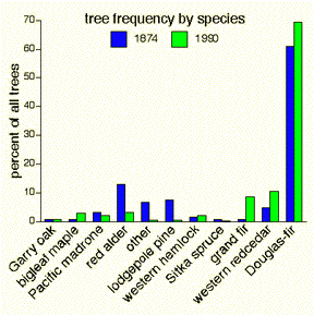
- What is the proportional distribution
of trees by species? This is called tree frequency.
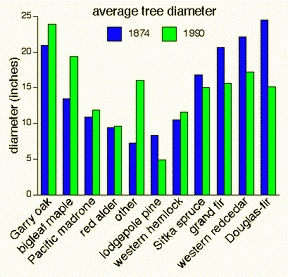
- How do average tree diameters
compare?
- Which species have more or less
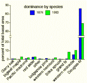
wood volume? This measure is simulated by the technical term
relative dominance (or proportional basal area). This
is the product of multiplying a species' average diameter by
that species' frequency. In actuality, basal area is cross sectional
area but it mimics tree volume fairly accurately.
The
present analysis omits actual numbers of trees and therefore
also tree densities at the two dates. Such density analysis
is possible but it has not yet been carried out in full detail;
suffice it to say, the preliminary conclusion is that at maturity
pre-settlement forests were stocked with fewer but larger trees
than occur in today's forests. Even so, forest stands were very
diverse in character. Broadly speaking, there may be as much
wood in today's forests as in 1874, but the average trees today
are about half the diameter and much closer together so that
today there may be about three times as many trees as before
settlement.
The
chart above shows tree frequency by species in 1874 and
in 1990. Long ago, just as today, Douglas-fir stems were vastly
more abundant than stems of other species. Comparison of the
data shows that the pre-settlement forests had somewhat higher
proportions of red alder and pine than now and somewhat lower
proportions of grand fir, redcedar, and Douglas-fir.
The
chart below shows that conifers in the pre-settlement forests
were somewhat larger in diameter in 1874 than they are
now. The difference is most apparent in the commercially valuable
species at the far right. Conversely, decidous or broadleaf trees
are larger today. Bigleaf maples are notably wider now than they
were 116 years ago.
"Relative
dominance" in San Juan County's forests is depicted
below. This chart demonstrates that the Douglas-fir is - and
was also in former times - the overwhelmingly dominant species.
Douglas-fir accounts for three-fourths or more of the wood in
our forests; this is because it is both quite large and clearly
the most abundant tree. From 1874 to 1990 this important species
declined in dominance from 86% to 69%, probably as a consequence
of being high graded for its commercial value. Grand fir, redcedar
and bigleaf maple have increased in dominance.
In
conclusion, these brief comparisons begin to illustrate some
of the changes that have occurred in the composition of our forests
over a period of 116 years. Growth, cutting, natural disturbances,
clearing and forest grazing in the past have all impacted our
forests and helped to create what they are today.
|
|
|