|
 |
 |
||
|
today's forests |
|
forest history The Presettlement Forest |
||
 |
|
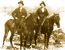
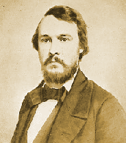
00As they approach to the town of Friday Harbor on San Juan Island, today's tourist-laden ferries glide past the University of Washington's marine sciences field station. Behind the small bayside campus of laboratories, just north of town, a dense evergreen forest sweeps up the south-facing slope of Point Caution. The forest that seems indistinguishable from other second-growth or regeneration stands in the much-logged San Juan Islands. However, that resemblance is deceptive. It is actually a new forest that recently overtook a large, centuries-old meadow or prairie, the existence of which has faded from memory. We will learn about the forgotten prairie and the process of its replacement by mature forest as we follow a trail of diverse and often minute clues. Although similar prairie-to-forest transformations may have occurred elsewhere in the Pacific Northwest, the focus of this story is the singular history of this one small parcel of land.1 00Today the south-facing slope of Point Caution is canopied by 100-foot Douglas-firs and lodgepole pines; at knee level there is an undergrowth of Wood's rose, sword fern and salal. Except for the campus lawns and buildings near the shore, the only natural breaks in the blanket of forest are a handful of small, moss-covered and treeless outcroppings of bedrock. In springtime their sparse soil hosts chocolate lilies, indigo-colored camas, and other sun-loving wildflowers that are not found in the shaded and deeper soil of the surrounding forest. The popular assumption that Point Caution had always been thoroughly forested was never critically questioned until an old document revealed, in a single phrase, that in the early 1870s a rancher named McCarty occupied the site. Because the early history of the San Juans is quite well studied, it was intriguing to encounter a new and previously unnoticed personality from the rough-edged years that preceded the era of official homesteading and settlement, especially because the known pioneers all gravitated to more hospitable and open sites, not a dark coniferous forest. One might presume that anyone living within the forest would be engaged in logging, not ranching, yet timber extraction in the San Juans commenced years later, well after the 1870s. So what was McCarty doing there? This puzzlement caused the man McCarty to become a focus of enquiry; the process of uncovering this man's personal story led stepwise into the forgotten story of the land that he occupied. 00Census records show that Thomas McCarty first landed on San Juan Island early one summer morning in 1859, when the island was still a decade and a half away from permanent settlement by Euro-Americans. He arrived as a 23-year-old private in the U.S. Army, along with some 60 fellow infantrymen, most of whom shared his Irish birth.2 The brigade had traveled under cover of darkness from Fort Bellingham to a beach on the south end of San Juan in order to contest Great Britain's proprietary claim to the whole archipelago.3 The soldiers planted their flag and constructed American Camp within shouting distance of the rudimentary outpost of Hudson's Bay Company (HBC). That Crown-chartered British trading firm had been raising sheep for a few years on a grassland it called Home Prairie, across the strait from its headquarters at Fort Victoria on Vancouver Island. The U.S. troops immediately attracted camp followers, who threw together a cluster of disreputable shanties euphemistically called San Juan Town.4 As military records show, within his first month McCarty was sternly disciplined for carousing in that scruffy enclave.5
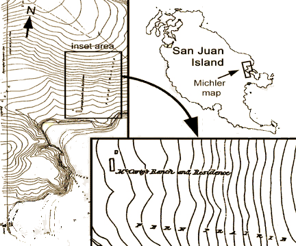
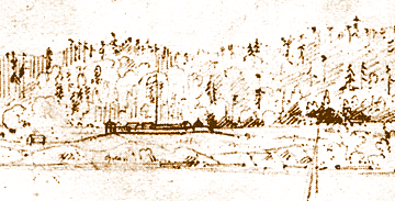
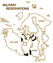
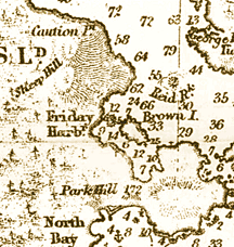
000The territorial dispute called the Pig War between Great Britain and the U.S. persisted peacefully for 13 years as a joint military occupation of the island. Until the conflict was resolved in 1872, few civilian settllers were permitted in the San Juans. Somehow, McCarty was one of the rare exceptions and became one of a handful of individuals to witness the island's full transition from military no-man's-land to prospering American farming community, even though he himself was never well-off. The 1870 census lists Thomas McCarty, age 35, as a civilian married to an Indian woman named Kitty and father to five-year-old Charlie. 6 000Once the boundary dispute was resolved, the opposed military forces withdrew from the island. In 1874, the U.S. General Land Office (GLO) arrived to survey the newly acquired islands. The approximate location of McCarty's home was referred to in the GLO Field Notes in an otherwise-unoccupied area seven miles north of San Juan Town, at the southwest toe of Point Caution hill a few hundred feet inland from the north shore of the little bay called Friday Harbor (the town of that name would not be founded for several years). Though not spotting the actual site, the GLO surveyor crossed a track and declared "A wagon road, leading to McCarty's ranch." This comment is at once casual and startling: it refers to a place that today is so densely forested that one cannot imagine how any real ranching could have been possible.7 GLO surveys laid the groundwork for dispensing homesteads, yet neither homestead plats nor legal documents mention a Thomas McCarty or anyone else in the Point Caution area.8 000The most likely reason that McCarty's road was identified, while his ranch was not recorded as a homestead, is that he was an unsanctioned squatter on the land. Regarding the land, once the Pig War was concluded, Point Caution was set aside as public land unavailable for homesteading or other private ownership, a status that it retains to this day (though originally federal, it has since become state land). That is, the U.S. Army designated Point Caution as a military reserve, one of six large parcels facing the inner waters of the archipelago, presumably as hedges against any resumption of military tensions with Britain. The decision to withhold the land from homesteading and secure it for military uses prompted the army to start accumulating a file of documents relating to the land, and in most cases squatters were discovered. Regarding the Point Caution reserve, a map executed by General Nathaniel Michler in 1874 lays out its basic topography, land-cover, and anchorages; it will be noted that the Michler map is exactly contemporaneous with the GLO survey that mentioned McCarty only in passing (even though the two federal agencies never really worked together). The map includes two small rectangles labeled "McCarty's ranch and residence," thus pinpointing important details that had been omitted in the GLO survey. In an even more telling label, "FERN PRAIRIE" is boldly inscribed across the lower portion of Point Caution hill; that term was conventional in the 19th century for describing open land covered in bracken and grasses.9
000While the Michler map firmly places McCarty on a landscape that is very different from today's, two textual documents associated with the map, but archived separately from it, elucidate matters even further. One, a brief note of transmittal that doubtlessly accompanied the 1874 map, simply stated, "The whole of the southern end of the reservation is included in the claim of McCarty." The tolerant tone hints that the unauthorized occupier asserted some unrecorded preemptive right to the land or was even accepted as its de facto caretaker, rather than singling him out as a nuisance to be expelled.10 The second document dates from 1876, when an Army captain re-visited all six military reserves in order to describe and appraise the various squatters' dwellings that had turned up in Michler's surveys, conceivably in case the occupants would need to be evicted and compensated during a military emergency. For the Point Caution land, the captain noted:
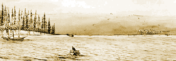
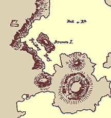
00This invaluable little document clinches McCarty's connection with fenced sheep and a field that was treeless and grassy enough for grazing, for the animals could not be expected to forage in a closed forest. But this picture may leave a misleadingly positive impression: it is well-known that too many sheep confined by fences can overgraze tender, native Pacific Northwest grasslands and cause landscape degradation. Given Thomas McCarty's background, it cannot be blithefully assumed that he was a consciencious steward of the land. 000Today, the 450-foot-high hill at Point Caution has no accepted name, although as far back as 1859 a British naval chart maker intriguingly labeled it "Sheep Hill."12 As we have learned from the Michler documents, some of the hill's lower slopes had been treeless and grassy just 15 years later, so perhaps higher and more visible slopes were once also open enough for grazing livestock, thus accounting for the hill's name. But if sheep were seen on Sheep Hill in 1859, whose livestock could they have been? Not McCarty's, because in that year he was stll a rowdy army private bivouacked at American Camp several miles away. Other records strongly imply that someone else with sheep preceded McCarty on the same site. In the 1850s only one candidate possessed sheep. 000In 1853, HBC had brought about 1,300 sheep from Vancouver Island to grasslands at the south end of San Juan Island. They were the island's first sheep. Six years later, the herd had grown to 4,500 head, according to HBC business records. Flocks were grazed at a half-dozen free-range stations throughout the island, wherever forage was found in forest openings, and all the animals were periodically returned to Home Prairie for culling, shearing, and lambing. One HBC sheep station, known as Friday's Prairie or Channel Prairie, was overseen by a trusted Hawaiian employee surnamed Poalie (meaning Friday in English). Friday's station is repeatedly mentioned in HBC journal entries from 1858 to 1860, almost exclusively during the months of October to December, when the remote station was used for autumn grazing. Though its location was never explicitly identified in HBC records, the station was clearly linked to so-called Friday's Bay (today the bay is called Friday Harbor) several miles north of Home Prairie, probably within easy view of the hill at Point Caution. If grasslands were present on that hill, then Friday's free-ranging sheep at times could have roamed or been led high enough to be observed by Royal Navy mapmakers. It seems tenable, then, that the naming of Sheep Hill in 1859 was inspired by observations of HBC sheep, probably by passing navigators alert to notable landmarks. This possibility gains traction with the next discovery that Friday's station can now be shown to be located precisely on the foot of the hill. 000Two historical narratives place Friday's meadowland exactly where McCarty's ranch was later reported to be. The first document had its genesis in the British response to the occupying American troops; Britain felt obliged to establish a countervailing force on San Juan Island in order to preserve its own claim of ownership. Accordingly, on February 23, 1860, seven months after McCarty landed with the U.S. troops at the island's south end, a Royal Marines captain dutifully scouted sites for another potential encampment. Although his superiors ultimately deemed none of his options suitable (and subsequently selected Garrison Bay), the captain's personal favorite was:
An appended sketch map placed the chosen site northwest of Brown Island and north of Beaverton Cove, exactly where McCarty's Point Caution ranch was be situated a dozen years later.14 000By coincidence, one month before the British memo was drafted American civilians had described the same scene. On January 28 a small team in a U.S. Northwest Boundary Commission boat took refuge from difficult channel currents. An expedition member recorded in his journal,
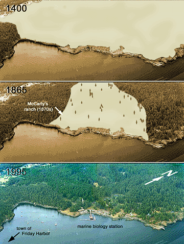
00These two eyewitness accounts attest that in the 1860s the open and unoccupied land around Friday's Bay was becoming known to a widening circle of island inhabitants and visitors. When Thomas McCarty sought a place to settle, probably later in that decade, the largely treeless land, with a proven potential for ranching, must have presented a ripe opportunity. Knowingly or not, Irish-born McCarty seems to have followed in Hawaiian-born Friday's footsteps, both geographically and occupationally. Neither was constrained by procedures of legal land ownership; they simply moved onto the land in order to make a basic living. 00The foregoing written documents, then, substantiate that Point Caution was a prairie upon which sheep were grazed from the 1850s to the 1870s. Additional insights into the pre-modern landscape come from two graphic documents: a long-overlooked map and a fortuitous old photograph, both from 1895.
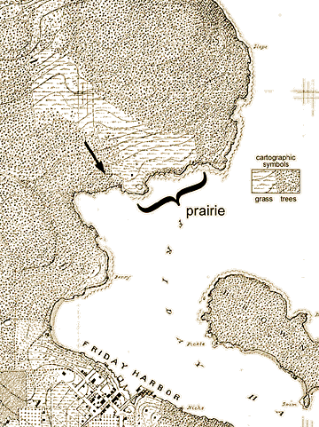
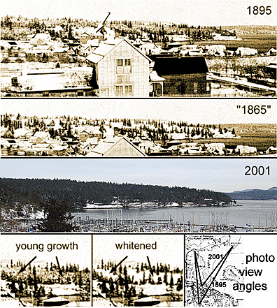
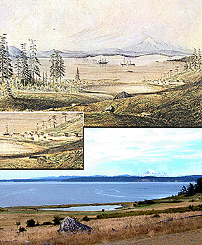
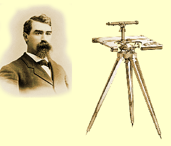
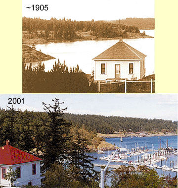
000Over several years in the late 1800s John J. Gilbert, a surveyor and draftsman with the U.S. Coast and Geodetic Survey, created a series of fifteen magnificently detailed large-scale, topographic, land-use and land-cover maps of San Juan County. They were never published, and even their purpose is unknown; manuscript versions were archived and only recently rediscovered. The 1895 map covering the Point Caution area shows a 60-acre, treeless prairie bordered by forest that extended from the north shore of the bay up the middle slopes of Sheep Hill.16 000In the same year that Gilbert created his Point Caution map, an anonymous photographer captured the same prairie in such lucky circumstances that the image vividly reveals the ecological process that was changing the landscape. The image was recorded on a gloomy winter day in 1895 soon after a light snowfall. In the foreground we see the young town of Friday Harbor, which had been founded only three years before, but the background includes much of the Point Caution landscape, of course much foreshortened.17 The combination of a snowy blanket and flat lighting allows us to distinguish three zones of vegetation that would not otherwise stand out: 1) uniformly white areas located predominantly close to shore and on lower slopes that signify bare ground or very short vegetation (such as snow-covered grass); 2) about a hundred tall, deep-crowned coniferous trees scattered singly and in small clusters, which appear dark because they have shed their loads of snow; and 3) extensive mottled areas of intermediate height (presumably comprising snow-spattered shrubs and young trees) that occupy most of the upper and middle slopes of land. The photograph seems to document a meadow in the process of being engulfed by an invading young forest. The towering conifers evidently constitute a small cohort of old trees that had dotted the slopes for many years preceding 1895.
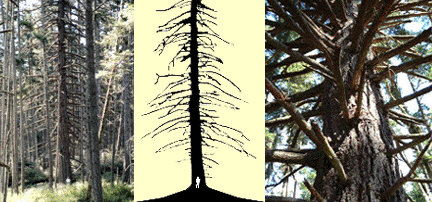
00It stands to reason that the prairie was larger before the forest encroached; land that was occupied by young trees in 1895 must have been open prairie before those trees got established. Accordingly, by graphically subtracting the invasive growth from the image (that is, by erasing the mottled areas of the photograph), we can simulate a glimpse of a time before the invasion began, when the prairie was larger than when it was photographed. Such a reconstruction has been achieved by digitally converting all mottled zones to solid white, a kind of photographic makeover in which all intermediate-height vegetation is made to resemble open ground or grassland (morphing zone 3 into an expanded zone 1). If we further postulate that the invading vegetation, just removed by the makeover, was about 30 years old in the year of the photograph, the reconstructed image simulates a landscape as it might have appeared in 1865. Such an expanded prairie, then about 125 acres in extent and still dotted with large trees, likely resembles what the shepherds Friday and Thomas McCarty saw when they successively inhabited Point Caution with their flocks. 00Now that we have exhausted the documentary evidence for the existence of a Point Caution prairie, we should consider the natural history of the land itself. Although the gradual transition from prairie to forest is presently complete, some physical evidence of the change still exists. Several questions are raised by the actual trees on the south-facing slopes of Point Caution hill: Did most of them really germinate around 1865, as the reconstructed photograph suggests? Did they regenerate within the wreckage of a pre-existing forest, replacing it as second growth, as conventional presumptions have always held? Do the trees themselves present any evidence to tell us that they emerged from a treeless landscape such as a meadow or prairie? 00A walk through the forest of today reveals great homogeneity: over 95 percent of the trees are medium-sized Douglas-firs and the rest are lodgepole pines of similar size. Because both of these species require considerable direct sunlight for germination and growth, neither could have prospered from seedling to mature tree in the shade of the other; so they must have grown up together and should be the same age. This hypothesis has been supported by counts of annual growth rings; scores of Douglas-firs felled by windstorms between 1990 and 2000 (and subsequently cut up for firewood) proved to be 100 to 130 years old, with older trees generally located farther uphill. These data confirm that today's forest germinated between 1860 and 1900, and they are consistent with a down-slope wave of germination. 00By conventional criteria, the forest resembles an even-aged, second-growth stand. The density is about 300 well-spaced trees per acre; trunks are uniformly about 16 inches in diameter and devoid of branches for the lower half of their 100-foot height; the green canopy is formed of short crowns all crowded together at the same height. These features typify second-growth stands in other places that replace forests leveled by cutting, violent windstorms, or intense burning, but the Point Caution forest lacks the expected physical hallmarks of any of these stand-replacing these events, such as heavily charred debris and abundant charcoal, jumbles of rotting trunks and mounds of degenerated root wads, or numerous old stumps and remains of treetops abandoned after logging. Accordingly, lacking evidence of past forest fires, powerful windstorms, or extensive logging, logic dictates that the forest of Douglas-firs and pines arose within an environment that was already open, such as a prairie. If so, the forest is decidedly not second growth, even if it is even-aged. Except for about one hundred large, old trees, the Point Cation forest is "brand new" growth. 000Some readers may doubt that Point Caution escaped widespread logging, because folklore adamantly asserts that every inch of the San Juans was fully logged in the past, often more than once. Although this article is not the place to review the history of island logging, suffice it to say that the local folklore exaggerates. In broad terms, logging was nonexistent in 1865 and was not extensive until about 1900, when commercial limekilns began consuming massive quantities of fuel wood for the next 60 years.18 Furthermore, the first significant logging for lumber in the San Juans was deferred until World War II because of many factors: the relative inaccessibility and poor quality of local timber; the minuscule capacity for on-island milling; a negligible local consumer base; prohibitive costs to transport lumber to mainland markets; lack of labor and logging machinery; and competition from larger producers elsewhere in the state. Even clearing of forest for farmland has never been necessary on a large scale because naturally open grassland and bottoms were fairly abundant. Finally, in regard to the Point Caution forest, logging was specifically prohibited on federal reserve lands. 000Despite a high degree of uniformity among the century-old, bare-trunked Douglas-firs and pines previously described, a few exceptional trees deviate dramatically in form. These are the trees that clinch the idea that the Point Caution area used to be a prairie; their unique story emerges from from their unusual morphology and underlying biological principles of tree growth. At least twenty distinctively solitary "wolf trees" are found scattered throughout the forest; these peculiar and obviously very old Douglas-firs occupy immense spaces, in part because their thick trunks bristle with large, dead branches. Their rough-barked trunks measure 3 to 7 feet in diameter, and they exhibit low branches that are 4 to 15 inches in diameter (something that typical forest-grown Douglas-firs do not). Loggers everywhere have long avoided cutting wolf trees because their wood is so knotty, a testament to their long-retained branches. In the mid-1990s, forestry students from Seattle collected core samples from several of the Point Caution wolf trees and counted 300 to 600 annual growth rings per tree, signifying that these few specimens germinated between the years A.D. 1400 and 1700. These venerable trees, then, must represent the deep-crowned old specimens that stand out so boldly in the snowy 1895 photograph of Point Caution. In the 1865 photo reconstruction, they tower as sentinels over the open prairie landscape that was just then in the process of disappearing by sapling in-growth.
000Because a great deal is known about the growth characteristics of Douglas-firs, these relict wolf trees can tell us much about an open prairie that surrounded them in their youth, long before Europeans or Americans arrived. But the analysis is technical. The argument that follows relies on certain traits of shade-intolerant Douglas-firs: lateral branches originate exclusively from buds just below the growing terminal; each branch's position relative to the ground remains fixed; and each branch can remain living and green so long as it receives sunlight, growing thicker over the years. Therefore, the retention of any exceptionally large branch means that it remained alive and growing for a long period without being retarded by shade from any neighboring tree or structure; and if that branch is situated very low on the tree, and is thus nearly as old as the entire tree, then the tree's period of growth in the sunny open must have been continuous from the date of the tree's germination. Conversely, whenever a Douglas-fir branch is seriously shaded, it soon dies, even though unshaded portions of the tree survive. If the branch dies while young and still thin, it sloughs off the trunk leaving hardly a trace; if it is older and thicker when it dies, its remnant stub may remain attached to the trunk for years or decades before it fully rots away. All of these conditions can be seen in Point Caution's Douglas-firs, and each recounts a different portion of the history of the landscape. 000The main cohort of 100- to 130-year-old, bare-trunked trees lost their lower branches early in life, presumably because of mutual shading by close neighbors; the rare and older wolf trees, in contrast, which germinated centuries earlier, evidently grew widely separated and retained living branches for very long periods (from about A.D. 1400 to about 1865, which allowed such branches to attain great thickness) before being finally killed about a century ago by the shade of some nearby, younger tree. The structure of the ancient wolf trees also shows that for most of their long lives, they thrived and grew thicker in the full sunlight afforded by an open landscape, such as a prairie. The trees, therefore, show that the landscape around Point Caution hill could not have been densely forested for some centuries prior to 1865. Using simple logic, the present ages of the ancient wolf trees suggest a minimum number of centuries during which prairie conditions predominated. 00If we can finally accept that a prairie previously existed where now there is forest, it remains for us to conjecture how that prairie originated, how it remained essentially free of trees for at least 500 years, and what factors allowed the forest to eventually overwhelm it. When Europeans first disocovered the region in the late 18th century, occasional coastal prairies dotted the Pacific Northwest's landscape. These sunny openings contrasted sharply with the awesome and oppressive matrix of coniferous forests. They caught the eyes of early explorers, who romanticized the prairies as providential benefactions that beckoned settlers accustomed to European landscapes to establish ranches, farms, and orchards.19 Not until the mid-19th century did observers begin to recognize that the coastal prairies and some other forest openings were not entirely "natural," but rather had often been intentionally created by indigenous people. In 1860, while scouting railroad routes in western Washington, the insightful young naturalist James G. Cooper wrote:
00Archeologists have determined that Native people used to occupy Point Caution: the shoreline contains the eroding remains of three shell middens, although none has been dated or excavated. So, even though the ancient origin of the Point Caution prairie may be irretrievably lost to history, it seems reasonable to assume that Native people kept it open with periodic, low-intensity burning from at least A.D. 1400 to 1850. As Cooper suggested, such indigenous people presumably managed the prairie in order to exploit edible bulbs of the sun-loving camas and chocolate lily, whose few descendants still bloom on Point Caution's sunny, moss-covered outcrops of bedrock. As a managed, cultural landscape, even if it were seriously occupied only seasonally, the Point Caution prairie would have enjoyed the same accessibility, salubrious south-facing aspect, and exploitable productivity as hundreds of other archeological sites in the San Juan Islands. 21 00If Native people successfully maintained the prairie for so many generations, why and how did it collapse? As most of us now know, aboriginal people almost everywhere, including in the Pacific Northwest, experienced devastating contractions of culture, economy, and population as a result of contact with Europeans and Americans and their advancing settlements. Once abandoned by Native people, traditional lands as attractive as coastal prairies would have been readily appropriated by the newcomers. As open grasslands changed hands, ecosystem management based on intentionall ow-intensity burning was usually and abruptly supplanted by something that the land had not previously experienced, namely grazing livestock. At Point Caution conceivably as little as a decade or two of idleness separated the cessation of seasonal harvests of edible bulbs by indigenous people and the introduction by newcomers of livestock grazing sheep. 00Of all the human actors at Point Caution
from ancient times to the present, none evidently perceived that
the changes in land-use were consequential, let alone revolutionary.
Nor are any of the early players specifically remembered today,
at least as defined individuals. Granted, Poalie's Anglicized
nickname has been memorialized in the names of the bay and the
town of Friday Harbor, but nothing is recalled of the Hawaiian
shepherd himself. Likewise, Thomas McCarty's name barely surfaces
in the historic record. Indirectly, however, the sheep that these
two characters brought onto the Point Caution land may have left
the most lasting legacy as agents of accelerated ecological change;
their presence would have compounded the consequences of discontinued
periodic burning. As the first livestock on the land, and being
notoriously insatiable, grazing sheep could easily have devastated
the tender native grasses, especially McCarty's sheep that were
confined by fences rather than allowed to range freely (as Paolie's
had). Their sharp hooves also likely disturbed the soil and exposed
it to sunlight so that seeds blown in from nearby lodgepole pines
and Douglas-firs would have germinated explosively. This process
began at the far margins of the prairie in the 1850s and accelated
thereafter in a downward sweeping wave of sapling growth until
the entire prairie was swallowed by a young, growing forest.
00Today, a fairly larger area west of the foot of Point Caution hill, one that extends well beyond the narrow study area of this account, shares the same forest character and all lacks evidence of a preexisting forest, notably the absence of any large, old large trees and the corresponding absence of large stumps or other evidence of logging activity. The larger area is so uniformly covered with a single cohort of relatively young trees today that, even though explicit documentary analysis is restricted to only a portion of it, the prehistoric extent of the contiguous grassland probably covered a total area of one thousand acres or more. Unknown events of aforestation may have fragmented or reduced that large prairie to only a few hundred acres by the time free-range sheep were introduced in the 1850s. By 1865 possibly only 150 acres of prairie remained, and soon thereafter overgrazing prepared the site for a rapid final invasion by conifer seedlings. In order to account for the age distribution in today's forest, successive waves of germination from 1860 to 1900 must have passed down the slopes of Point Caution hill, an invasion process that was serendipitously captured in the 1895 photograph as a thicket of saplings and brush advancing toward the shore.22 By the 1920s and 1930s, young trees must have essentially obliterated the prairie, except for a few acres of open land near the shoreline where the University of Washington built its field station. Over subsequent decades, the institution focused exclusively on marine science and adopted a hands-off management policy toward the terrestrial vegetation on its 500-acre parcel, which allowed the immense cohort of young trees to grow into the dense forest that carpets the slopes today. Inattention over the past century has allowed any initial awareness of the earlier prairie simply to vanish from memory. 00Currently, as observed from a passing ferry, there is no hint that a Point Caution prairie once existed, and the forest appears permanent, even stable. Yet in reality the forest is no more immune to change than the prairie, for it has recently begun to unravel as pockets of root disease destroy trees that are too close together and as stubborn exotic plants, such as English holly, invade and propagate. Thus, subtle ecological change and landscape drama at Point Caution will continue into the future, even as some of its forgotten past has been rediscovered. 00Note 1 The seminal work in regional environmental history is Richard White, Land Use, Environment, and Social Change: The Shaping of Island County, Washington (Seattle, 1980). However, the book concerns an adjacent county, and its applicability to the San Juans must be tempered by recognizing significantly distinctive geologies, climates, and social histories. (return to text) 00Note 2 U.S. Census Bureau, "First Federal Census of Washington Territory, 1860, Whatcom County, San Juan Precinct," transcript of manuscript at San Juan Island Historial Museum. (return to text) 00Note 3 For comprehensive histories of the boundary dispute in the San Juans, see Hunter Miller, San Juan Archipelago. Study of the Joint Occupation of San Juan Island (Bellows Falls, Vt., 1943); David Richardson, Pig War Islands: The San Juans of Northwest Washington (Eastsound, Wash., 1971); and Michael Vouri, The Pig War: Standoff at Griffin Bay (Friday Harbor, Wash., 1999). For issues that compounded the dispute, see: Netta Sterne, Fraser Gold 1858! The Founding of British Columbia (Pullman, Washington State University Press, 1998); and Robert E. Ficken, Unsettled Boundaries: Fraser Gold and the British-American Northwest (Pullman, Washington State University Press, 2003). For a contemporaneous sketch of Fort Bellingham (1857) see James S. Whiting, Forts of the State of Washington (Seattle, published by J.S. Whiting, 1951), page 18, and see below. For a contemporaneous sketch of the U.S. Army landing on San Juan (1859) see "Camp at San Juan Island" (digital image #3728968) in Yale University's Beinecke Collection at http://beinecke.library.yale.edu/photonegatives, and see below. For a photograph of the adjacency of American Camp and HBC buildings (1859) see online digital image #3728968 "Camp at San Juan Island," of Yale University's Beinecke Collection at http://beinecke.library.yale.edu/photonegatives, and see below under Note 13. (return to text)
00Note 4 For a watercolor of San Juan Town (1859), see Franz R. Stenzel, James Madison Alden: Yankee Artist of the Pacific Coast, 1854-1860," (Fort Worth, Tex., 1975), plate C-28, and see below.
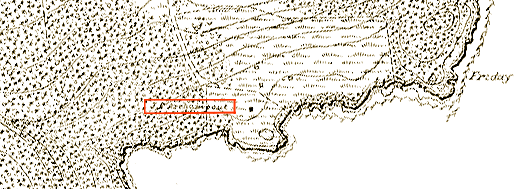
Note 5 For McCarty's indiscretions and harsh punishment, including "ball & chain weighing twelve pounds attached to his left leg," see Capt. L.C. Hunt, Commander, American Camp, August 23, 1859, Special Order No. 97, General Court Martial, Military Records, Records of the United States Army Continental Commands, 1821-1920, Record Group (RG) 393, National Archives and Records Administration (NARA), Washington, D.C. In late 1859 Capt. Hunt endeavored to to quell the disruptive influences of San Juan Town in a two-pronged approach: by disciplining his troops and by shutting down the town's civilian-owned "whisky shanties" and arresting the operators for "dealing poison to my men." Thirty "actual settlers" and "tillers of the soil" applauded the shut-down, and ten "tradesmen" protested in writing. One of these "transient... illicit Liquor dealers" was Frank Chandler, who years later became Thomas McCarty's nearest neighbor in the Point Caution area as another squatter (see Note 7, below). We may assume that their acquaintance originated in the wild, bawdy days of San Juan Town. (return to text) Note 6 "U.S. Census, 1870, Whatcom County, The Disputed Islands," Bulletin of Whatcom Genealogical Society 1-12, photocopy available in San Juan Island Historical Museum, Friday Harbor, Washington.U.S. (return to text) 00Note 7 U.S. General Land Office. "Field Notes, San Juan County," 1874, manuscript and typescript copies at San Juan County, Department of Public Works, Friday Harbor. In addition to mentioning McCarty, the GLO notes also refers to "Chandler's Prairie" at a location not far from McCarty's; it cannow be argued, with the aid of the following set of figures, that Chandler's Prairie is identified with McCarty's friend Frank Chandler, mentioned in Note 5, above, and like McCarty not a registered homesteader. The following detective work may seem tedious considering its payoff in relation to the main thesis, but such are the revelatory delights of picky analysis.  The above figures identify the Pt. Caution area in three, precisely registred images (a,b aerial photo from the Web Soil Survey, 2009; c,d USGS quad sheet "Friday Harbor," 1949 base with 1989 updates in purple; and e,f USC&GS T-sheets #2230 and 2231 of 1895. Rectangular boxes in (a), (c), and (e) are shown magnified in (b), (d), and (f), respectively. Horizontal and vertical thin red lines in panel (c) are integral to the published quad sheet and indicate section lines that were originally surveyed by the GLO in 1874. Red crosses in panel (a) and (e) superimpose the intersection of these lines (the section corner) onto the other images. In panel (c) numbered red arrows (GLO-1 through 4) identify four points along the east-west section line (horizontal red line) that are specifically mentioned in the GLO Field Notes. Additional labels will be explained in the following text. Frank Chandler's putative homesite is shown in detail in panel (f). It includes a dwelling (FC), a shed (open rectangle, a fenced orchard (or), a fenced cultivated field (cf), and fenced grasslands (g). It is situated at the end of a short track that branches from a road (r) that will later become Roche Harbor Road. The spread is about one mile from the town of Friday Harbor, three-fourths of a mile from Thomas McCarty's ranch, and a quarter mile from the boundary of the Pt. Caution Military Reserve. The precise location of Chandler's dwelling is reproduced by a blue X in panels (b) and (d), where they correspond very closely to the lower portion of Hillview Lane (constructed around 1970) near its intersection with Roche Harbor Road. The housing development served by Hillview Lane is called Hillview Terrace and the landscape is about one half open/half treed on a steep southwest-facing slope of Pt. Caution Hill. In the 1895 T-sheet the site bears no occupier's name, and the conclusion that it was Frank Chandler's is based on circumstantial evidence. That is, in 1874 when the GLO surveyed west-to-east along the horizontal section line shown in panel (c), the field notes recorded at position GLO-1 "To steep ascent N.E. & S.W;" at GLO-2 "Top of steep ascent;" and at GLO-3 "To Chandler's prairie N. & S." The field notes at the section corner (GLO-4) summarized the landscape between GLO-3 and GLO-4 as "Chandler's prairie high rocky land covered with clumps of young fir & pine." The surveyors passed only 200 feet away from the improvements (recorded twenty-one years later in the T-sheet), but it is not surprising that they omitted any direct mention of them; their charge was to document features directly on section lines and not to remark much on anything else. It is also possible that improvements in 1874 were much less substantial or visible than they were in 1895. Nevertheless, the Chandler name is specifically associated with a settled site just over the hill from McCarty's ranch. Indeed, the reader will recall that the GLO's south-to-north survey in 1874 recorded "A wagon road, leading to Mc.Carty's ranch E. & W. ascend rapidly." The specific location of that observation is indicated in panel (c) by a short green line, which happens to lie between McCarty's dwelling and Chandler's. Frank Chandler's name appeared in the territorial census of 1860 where he identified himself as a 28-year-old gambler. At about the same time his "whiskey shanty" near American Camp was shut down and McCarty was punished for misbehavior that most likely included partaking of Chandler's fare. Although no one with the Chandler surname appeared in subsequent censuses, the name nevertheless reappeared in the GLO field notes, as described above. These factors comprise the circumstantial evidence that the Frank Chandler is the same person that theGLO associated with the landscape feature "Chandler's Prairie." As a final note concerning the landscape, the point GLO-3 in panel (c), where the prairie was first identified in 1874, was characterized as forested by T-sheet symbols in 1895 in panel (f). Perhaps in the intervening twenty-one years the so-called "clumps of young fir & pine" grew to such an extent that the landscape had become more forested than open. Nevertheless, at points east of GLO-3, and certainly by GLO-4, the T-sheet of 1895 clearly depicted the landscape as prairie. In fact, at those points "Chandler's prairie" conflates with the upper reaches of the Pt. Caution prairie that is the princpal focus of this entire article. It is conceivable, therefore, that Chandler's, McCarty's and Friday's prairies were all continguous and part of the (speculatively) larger prairie landscape that covered this corner of San Juan Island in recent prehistoric times, and that persists today primarily as the dry, southwest-facing, open land of Hillview Terrace. Concerning Chandler and McCarty themselves, little more is recorded. Frank Chandler drops out of the record entirely after the GLO references to his prairie; there is no way of knowing whether the man himself was still on site even then, let alone in 1895, despite the present thesis that asserts that the 1895 location (panel f) corresponds with his homesite. Someone else could as easily have occupied the little farm, even if it had originally been Chandler's. As for McCarty, he was mentioned in 1890 in a newspaper notice regarding the proving-up of a neighboring homesteader, John. W. Johnson (see Bigfoot and His Forest of this website). The last known reference to Thomas McCarty is a notice in the Islander newspaper, April 25, 1895 of his death at the Steilacoom home for retired soldiers (see Smith, Lois, 1986, Birth, Marriage & Death Records, p. 3, typescript in San Juan Island Library, Friday Harbor). When McCarty left his Pt. Caution ranch is not known. It is perhaps timely to mention that close inspection of the 1895 T-sheet inscribes a name other than McCarty's at, or near, the location of his dwelling (as located in the Michler map). As shown in the image below, one J.C. Archambout (red box) was inscribed next to a dwelling (black square) and near three sheds (open squares). As recorded in the T-sheet, fences enclosed the prairie, surrounded the homesite, and demarcated a track or road that proceeded north northwest. Although Archambout is a surname that is found in early census and homestead records for a faraway part of the island, it is also a name that was associated with the Mullis house in Friday Harbor (see Endnote 17, below). J.C. Archambout evidently occupied the land after McCarty's departure, but he could not have been the owner, because it was still federal land. Based on circumstances that will be described next, he may have obtained grazing and livestock-tending rights from the U.S. Army.
Archambout's name has not been discovered among military records of the Pt. Caution site, but a few years later, in November, 1902, C.L. Carter 's name does appear. For $30 per year, Carter arranged a five-year lease with the U.S. Secretary of War for which "said premises are to be used by the lessee for grazing purposes only; that no buildings other than stock sheds shall be erected thereon... that the lessee will maintain the present line of fence in condition of effective repair... and that the cutting of timber on said premises will not be allowed." (Military Reserve Record, Pt. Caution Military Reserve, NARA I, Washington, D.C.). It is likely that both McCarty and, later, Archambout had similar, but less formal, agreements with the military whereby grazing rights were exchanged for occupancy and light maintenance. Finally, through the years Pt. Caution has been known by a wide variety of names: Channel Prairie, Friday's, Indian Reserve, McCarty's place, Government Point (used by ferry operators to designate the feature upon which the survey station "Friday" was located, see above figure), Cantilever Point (USGS quads), and even Carter's Point. Each name has its historical baggage; the military record cited above now clarifies the logic behind "Carter's Point," which merits a brief entry in Wood, B. (1980) San Juan Island. Coastal Place Names and Cartographic Nomenclature. Wash. Hist. Soc./Univ. Microfilams Internat., p. 132: "presumably named for C.L. Carter, a butcher in Friday Harbor, who ran a flock of sheep on the land currently occupied by the... Friday Harbor Labs."(return to text) 00Note 8 Homestead
records, San Juan County Auditor's Office, Friday Harbor. (return to text)
00Note 9 Nathaniel Michler, "Pt. Caution Military Reserve," Sept. 23, 1874, Shaw Island file, box 12, Military Reservation Maps, NARA (Pacific-Alaska Region), Seattle. (return to text)
00Note 10 Robert A. Haberstam, Ass't Engineer, to N. Michler, Feb. 2, 1875, Correspondence, box 1, Military and Indian Reservations, NARA (Pacific-Alaska Region), Seattle. (return to text) 00Note 11 G.H. Burton to Assistant Adjutant General, Dept. of the Columbia, Feb. 1, 1876, copy in Military Reserves on file at Lopez Historical Museum, Lopez Island, Washington. The assessor described McCarty's open land as "cleared," which implies that vegetation had been cut out. If it could confirmed that trees were logged out, that information would contradict the present thesis that no forest preceded the prairie at Point Caution. More likely, however, the assessor casually misinterpreted the treeless opening edged by forest as a created condition rather than a natural one when he assigned the participle "cleared" rather than the more neutral adjective "clear". (return to text 00Note 12 G.H. Richards, "Haro and Rosario Straits," 1859, Map Collection, University of Washington Libraries, Seattle; a copy is available online at www.wsulibs.wsu.edu/digital s.v. "Early Washington Maps," and see below. (return to text)
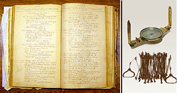
00Note 13 For HBC sheep operations on San Juan, see journal entries by Charles J. Griffin, various dates, "Belle Vue Sheep Farm, 1854-1855 and 1858-1862," photocopy of manuscript, San Juan Island National Historical Park Archives, Friday Harbor (original in Hudson's Bay Company Archives, Winnipeg, Manitoba). For the unresolved debate about Friday/Poalie's given name (either Peter, Joseph or Joe), see: Elizabeth O'Brien and Brenda Pratt, "Who was the real Joe Friday?" Newsletter of the San Juan Historical Museum, 1-3, Friday Harbor, Washington; Eileen M. Naughton. Hawaiians in the Fur Trade: Cultural Influence on the Northwest Coast, 1811-1875, Master's thesis, Western Washington University, Bellingham, 1983; and Tom Koppel, Kanaka. The Untold Story of Hawaiian Pioneers in British Columbia and the Pacific Northwest (Vancouver, Canada, Whitecap Books, 1995). (return to text)
00Note 14 James Prevost to R.L. Baynes Feb. 23, 1860, reproduced in Miller, pp. 132-33, and see below.
00Note 15 William J. Warren, "Geographical Memoir of the Islands between the Continent and Vancouver's Island in the Vicinity of the Forty Ninth Parallel of North Latitude," Jan. 28, 1860, International Boundary Commission, RG 76, NARA, College Park, Md. The original document has been lost, but an undated transcription by Greg Lange is on file at San Juan National Historical Park Archives.
00Note 16 John J. Gilbert, Topographic Sheet T-2230, U.S. Coast and Geodetic Survey, RG 23, NARA; the entire map series is available online at www.wsulibs.wsu.edu/holland/masc/sanjuanindex.html.For the original map, see: U.S. National Archives and Records Administration, Cartographic Division. U. S. Coast and Geodetic Survey, Record Group 23, Topographic Sheet #T-2230, John J. Gilbert, 1895. College Park, Maryland. This map and others in the series can be viewed online at www.wsulibs.wsu.edu/holland/masc/sanjuanindex.html. The author recovered all of these maps after viewing a fragmentary copy at a county-fair exhibit. showing fish traps off Cattle Point casually appeared in a SJ County Fair exhibit of the historic fishing industry. The fragment, unappreciated by its owner, was clearly part of a larger series,which turned out to be fifteen large-scale maps. Digital versions of full-scale photocopies were posted online with the collaborative assiatance of Washington State University (Pullman), University of Washington (Seattle), and Western Washington University (Bellingham). A full account of Gilbert's maps is presented in the page of this website entitled "Late 19thC Landcover."
00Note 17 Photographic print # HS 785-51 by an unnamed photographer (but probably James M. McCormick), Photographic Archive, San Juan Island Historical Museum. Because the original view from the 1895 photo point (house at corner of Caines Street and Argyle Avenue is now obstructed, the author's photo point for the 2001 image was a historic building (the Whale Museum, arrow in 1895 photograph), which resulted in a wider angle of view. (return to text)
00Note 18 Timber harvest statistics for San Juan County are reported online at http://www.rockisland.com/~tom/stats. (return to text) 00Note 19 For romantic impressions of coastal prairies in the Northern Straits, see entries for May 1 to June 6 in C.F. Newcombe, ed. Menzies' Journal of Vancouver's Voyage, April to October, 1792, (Victoria, B.C., 1923). (return to text) 00Note 20 James G. Cooper, Botanical Report, Reports of explorations and surveys to ascertain the most practicable route for a railroad from the Mississippi River to the Pacific Ocean made under the direction of the Secretary of War in 1853-5," (Washington, D.C., 1860), reprinted as "Plant Life of Washington Territory: Northern Pacific Railway Survey, Botanical Report. 1853-1861," ed. Alice R. Anderson, in Douglasia, Occasional Paper 5 (1994): 15-16. For intentional landscape burning by indigenous people, see Robert Boyd, ed., Indians, Fire and the Land in the Pacific Northwest. (Corvallis, Oreg.). For impacts on indigenous populations by infectious diseases, see Robert Boyd, The Coming of the Spirit of Pestilence: Introduced Infectious Diseases and Population Decline among Northwest Coast Indians 1774-1874. (Seattle, 1999). For a broad survey of indigenous influences on landscapes, see Charles C. Mann, 1491: New Revelations of the Americas before Columbus. (New York, 2005).
00Note 21 Gary C. Wessen. Prehistorical Cultural Sites in San Juan County, (Kirkland, Wash., 1986). (return to text) 00Note 22 The primary conclusion of this article, that a new forest recently encroached upon and obliterated an ancient prairie was preciently forecasted decades ago in a typescript analysis of vegetaion on the Friday Harbor Labs campus (Eaton, Charles M. 1975. A preliminary biological inventory of Friday Harbor Labs property, San Juan Island, Washington, on file at FH Labs). Eaton analyzed annual tree rings in fifteen trees on the same site as described in the present article and concluded that "between 100 and 125 years ago [before 1975, therefore 1850-1875], these trees began to establish themselves on this southern slope with very rapid initial growth as evidenced by the wide rings... It may be that in the early 1800s the southern slopes looked very much like thesouthern slopes of Mt. Dallas or Turtleback Mountain look today -- open grassland with scattered oldgrowth Douglas fir," pp. 12-13. In other words, present findings and Eaton's precisely concur. For encroachment by thickets of young trees elsewhere in the San Juans after the cessation of burning, see Timothy E. Goss "The Landscape History of Moran State Park," Master's Thesis (University of Washington, Seattle, 1995), and David L. Peterson and R. David Hammer. "From Open to Closed Canopy: A Century of Change in a Douglas-fir Forest, Orcas Island, Washington," Northwest Science, Vol. 75 (2001), 262-69. For an analysis of intentional burning in a forest stand similar to that at Point Caution, see Donald W. Spurbeck and David S. Keenum. "Fire History Analysis from Fire Scars Collected at Iceberg Point and Point Colville on Lopez Island, Washington State," USDA-FS-PNW-Wenatchee Forestry Sciences Laboratory and Okanogan and Wenatchee National Forest, 2003, www.fs.fed.us/pnw/wenlab/pages/pubs-index.html. (return to text) |