 |
 |
 |
||
|
pages about today's forests Home |
|
forest history |
||
|
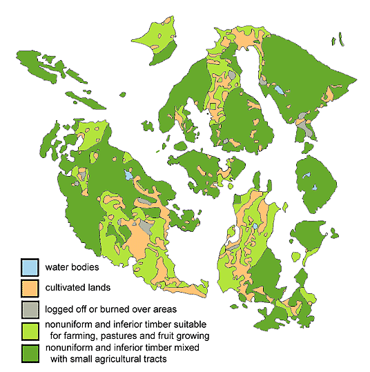
INTRODUCTION The earliest natural resource maps for western Washington dismissively panned the forestlands of San Juan County as inferior. Such blanket denunciations at first seem off-handed, improbable and unfounded in fact. But by considering them in their historical and broader geographical context, it becomes clear that by regional standards of forest productivity the San Juans did (and does today) indeed rank among the lowest in terms of priority for commercial exploitation, which of course was the main utility of the early maps. Gradually, natural resource maps became more scientifically valid, detailed, and objectively informative. Starting with those early maps, this article traces the development of maps of San Juan County that characterize its forest productivity. Their purpose today is less to denouce the forests and more to realistically describe their properties and capabilities. EARLY TIMBER-DENSITY AND LAND-CLASSIFICATION MAPS (1883 to 1910) In 1883, one decade after the San Juans became a county the US Dept. of Interior published a map entitled "Density of Forests in Washington State, 1883" which displayed geographic zones color-coded according to timber density measured in cords per acre (a cord being a stack of firewood 4 x 4 x 8 ft). Forests in the Cascade foothills and the Olympics were rated much higher, i.e. 100-200+ cords per acre. In contrast, the San Juan Islands were uniformly rated at a mere 2 to 5 cords per acre! If the timber volume of local forests was indeed that low, is it any wonder that the islands were neglected by Puget Sound's burgeoning logging industry? The cited map is not reproduced here) but it can be viewed online through the University of Washington Libraries website under the identity of "UWM 102" or "Y 1.1/2:serial 2137 map 1." In 1898-1902 the US Geological Survey created three maps (also not reproduced here) that again placed local forests in the lowest ranks. In one 1898 map entitled "Map of Western Washington Showing Density of Merchantable Timber," timber yield in the region's forests was designated by four color-coded categories that ranged from 2000-5000 board feet per acre (the lowest category) to 25,000+ board feet per acre. In that scheme San Juan County was left uncolored, indicating that its forests contained fewer than 2000 board feet per acre of timber. (For perspective, a fully loaded log truck of the kind used in the San Juans carries about 3250 board feet.) The second USGS map of 1898 was entitled "Map of Western Washington, Showing Classification of Lands." Enigmatically, it labeled every part of the San Juans as "Area From Which Timber Has Been Cut," even though in that era the county population of farmers and ranchers was not significantly engaged in logging, and the lime industry that ultimately consumed a great deal of fuelwood was still embryonic and had undertaken negligible logging. Incidentally, the same map labeled nearly all of Whatcom County as "Burnt Area," which designation is implausible, so one may seriously question the accuracy of its assessments on several grounds. Four years later, after revisions and additions, the USGS republished the latter map with the same title but updated to 1902, yet the entire San Juans were still classed as "Cut Areas." These three USGS maps may be viewed online as UWM 83 or G4281.K1 1898 .G4; UWM 17 or G4281.K1 1898 .R3; and UWM 1 or G4281.K1 1902 .P5, respectively. As reproduced below (redrawn for clarity), the USGS eventually created the much more detailed "Land Classification Map, Reconnoissance (sic) Survey. Puget Sound Basin, Washington, 1910" in which several land classes were distinguished and then further discriminated by "Uses of Land." The map curiously portrays a combination of existing landcover and suggested future utility, and as such is a clumsy merging of two objectives, but it is nevertheless interesting to see that the spatial separation between forestland and farmland (greens and orange, below) was then similar to what it is today. The terminology in the original map's legend is startling. First, all forestland in the San Juans was described as "areas of nonuniform and inferior timber growth," which probably reflects the observation that local conifers are shorter and more highly tapered than elsewhere and that the landscape is more highly irregular. In contrast, large forest tracts in the Cascade foothills were simply labeled "timbered areas." Second, the USGS prescribed that all of the forestland in the San Juans could and should, at least partially, be converted into farmland; the specific language for the light green areas below was "lands adapted to intensive farming, pasturage and fruit growing" and for the dark green areas below was "mixed lands or areas where small tracts of agricultural lands are scattered throughout extensive areas of non-agricultural land." In summary, early maps of our forestlands were mostly dismissive, if not outright defamatory. One beneficial aspect is that they may have helped to discourage industrial-scale commercial logging from the San Juans. |
||||
 |
||||
|
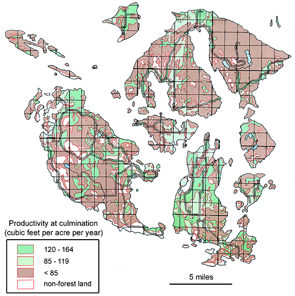
POTENTIAL FORESTLAND PRODUCTIVITY MAP, USDA (1980) The original Soil Survey for San Juan County, USDA (1962) mapped soil types and described their capabilities, but it did not include a useful map of potential forest yield and productivity. In a brief text of dubious local relevance, however, it did characterize four "woodland groups" with some qualitative comments. It also offered a table of highly generalized forest stand yields at various stand ages, but the quantitative values were probably not specific to conditions in the San Juans; the table makes reference to five Site Classes (1 through 5, with Site Class 1 being the most productive, although it is not occur the county). Eventually in 1980 the USDA created the Potential Forestland Productivity map, reproduced below. It appeared as a wall-mountable sheet ; although it was not accompanied by any explanatory text, it was probably a delayed by-product of the Soil Survey (1962). In that map extensive blocks of soil zones that occur in the soil survey were assigned to broad forest productivity classes expresed in cubic feet per acre per year. They were more or less equivalent to the site classes mentioned previously, The highest productivity class (165+ cubic feet per acre per year) was not represented in San Juan County. As rough approximations, 100 cubic feet = 500 board feet = one cord. This and similar maps conceal many subtleties:
|
||||
 |
||||
|
STATE SOIL SURVEY (1983) -- CUSTOM-MADE FOREST AND SOIL MAPS (AVAILABLE ONLY HERE) In the second half of the 20th century, Washington state's Department of Natural Resources replaced federal agencies in the task of examining and evaluating the state's soils, lands and forests, including lands that were privately owned. DNR subsequently published a 10-volume State Soil Survey (1983) that compiled all of the 1000 soil types of Washington's 39 counties and interpreted their capacities for forest growth, especially as affected by various timber harvesting techniques. This valuable, but little known, work is available in a few research libraries such as at the University of Washington; there is some evidence that its content and circulation were suppressed by the timber industry. Information from the original State Soil Survey is neither readily accessible nor directly comparable to the Soil Survey for San Juan County (1962), in part because it is not organized geographically (that is, not broken down by counties) and because the soil types, while ultimately the same as in county soil surveys across the state, are coded quite differently (numerically rather than alphabetically). For San Juan County this incompatibility has been reconciled in a derivative document that was created privately in 1999; it is a customized abridgement of the the State Soil Survey pared down to information pertinent to this county. The customization is available in local libraries on San Juan, Orcas, and Lopez Islands (search for "State Soil Survey") and contains much useful information,although only in text format. The soil-by-soil breakdown includes 1) soil and environmental characteristics such as most suitable vegetation (species and site index), organic layer thickness and soil depth, and hydrologic features (drainage, permeability, water capacity, etc.), as well as 2) forest soil management interpretations such as natural stability for forestry activities, consequences of timber harvesting (mechanical limitations, compaction due to equipment, etc.), and characteristics that might constrain forest regeneration (flooding, plant competition, windthrow tendency, etc.). Each parameter is fully defined in a glossary. These soil attributes and forestry interpretations are fundamental to understanding the possibilities and limitations that underlie forest growth, yet without maps the details are very awkward to retrieve from the original textual documents. The ten maps shown below have been constructed from data in the State Soil Survey in order to convey an overview of the broad issues confronting forest soils in the county. Their creation became possible because in the 1990s DNR incorporated the State Soil Survey (1983) into its so-called SOILS data base as part of a Geographic Information System. Even though DNR itself did not exploit the cartographic potential of this GIS, outsiders could privately combine the digital shape files of soil units with digital soil and forest attributes and an appropriate base map of San Juan County. The following maps were prepared in this way, thanks to technical asistance from Greg Frister. |
||||
 |
||||
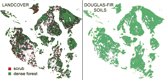
| The
above two countywide maps display existing forest landcover (left)
and the distribution of soils that are suitable for growing Douglas-fir
and may have done so in the past (right). In the San Juans soils
that are not suitable for Douglas-fir are either suitable for
red alder, are unsuited to trees altogether, or have been deemed
permanently converted to agricultural lands (shown in white,
right). Scrub occupies a large number of small areas, possibly
indicating pre-existing forest that has been removed and whwre
regeneration is in progress or has failed. It is noteworthy that
some large areas of past or potential forestland in central Lopez,
San Juan Valley and Crow Valley, Orcas, have been converted (to
pasture in most cases). |
||||
 |
||||
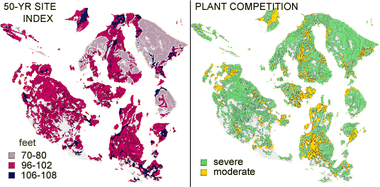
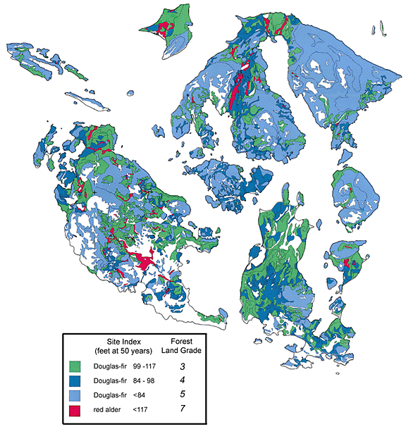
| Site
Index (above, left) is the projected height of the best trees
after 50 years of growth of an unmanaged natural stand (not to
be confused with what may presently exists on a site). Compared
to most mainland areas, these values are quite low, indicating
that conditions for height growth are harsh in the San Juans.
The map on the right indicates a major deterrent of stand regeneration,
namely that conditions for successful establishment of seedlings
after a timber harvest are severely impeded by brush invasion
and competition. |
||||
 |
||||
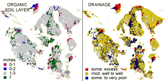
| Thanks
to past glaciation, soils in forested regions of the San Juans
are notably shallow; organic soil layers are thin (left, above)
and usually underlain by rock or clay. These conditions cause
shallow rooting depth and trees with numerous root problems that
poorly anchored. As shown on the right, much of the San Juans
is "moderately well to well drained," primarily because
terrain is frequently sloped. Areas that are natively poorly
drained also have the deepest organic soils; these areas have
mostly been been converted to pastureland after being ditched
to aid drainage. |
||||
 |
||||
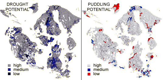
| Multiple
soil attributes are frequently coupled. In the forested hilly
areas of theSan Juans, thin well-drained soils tend to desiccate
(left, above) during typical dry summers. In the winter, the
same areas (except for parts of Waldron Island) experience considerable
puddling if timber harvesting occurs with heavy equipment. Vital
root functions (and therefore tree growth) will be adversely
affected by the double-whammy seasonal strangulation by soil
droughtiness and suffocation by drowning. |
||||
 |
||||
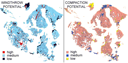
| High windthrow potential (left, above) means that many trees are blown down during strong winds and signifies that development of tree roots and/or of soil stability have been compromised. Compaction (right) occurs if heavy equipment conduct logging operations when soils are wet and vulnerable. The consequences of compaction are very long-lasting: the eliminination of vital soil oxygen (air), suffocation of soil microbes that are essential to tree nutrition, and stunted tree growth (especially of the roots). Diminished height growth, chronically low tree vigor, and high incidence of wimdthrow in the San Juans can all be attributed to compromised root function. | ||||
|
PRIVATE FOREST LAND GRADE MAP (1996) During the contentious Growth Management Act planning process of the 1990s DNR provided participating counties with specific information in textual and cartographic form concerning forest productivity (as directed by Washington Administrative Code 458-40, Vol. 11,1992). Their purpose was to help define "highest and best" land uses relative to such planning issues as rural residential densities and natural resource areas of "statewide significance." Maps displaying potential forest productivity were prepared by DNR's recently instituted digital data bases and GIS capability. In actuality, two versions of a large-format map were prepared for San Juan County, neither of which was formally published or made available to the public. The first version was sent to the county, where it became attached to the back of an always-open door in the county Planning Dept., and was thereafter virtually ignored. Unbeknownst to the county, the content of that first version of the map was "wrong" by its makers. A revision was prepared but never sent to the county. DNR prepared a revised second version of the map (the one reproduced below) that stayed in DNR. In what ways was the first version "wrong" that a revision was required? Soil scientists at DNR decided that forest productivity depicted in the first version created a misleadingly rosy picture of forest growth in the San Juans. They realized that soils in San Juan County, even if they were the same soil types that elsewhere in western Washington, were significantly shallower and rockier and were demonstrably less productive in terms of forest growth; in other words, theoretical soil capabilities had not been upheld by ground-truthing in the San Juans. Accordingly, DNR technicians "demoted" productivity of county's soils by an across-the-board reduction of 30% in their second map version, relative to the first version. The second version of the Private Forest Land Grade Map (dated 1996 and reproduced below) was discovered at DNR offices in Olympia. In the map below forest productivity was graded by site index, which is a simple measure that is tighly coupled to volumetric yield. The original map contains data for Douglas-fir, western hemlock and red alder, but for simplicity and accessibility western hemlock data has been omitted because it is such a minor constituent here (even though the county is formally part of the "Douglas-fir / western hemlock ecological zone"). DNR defined five productivity grades that were applicable to Douglas-fir throughout the state (Grades 1 to 5 in descending order of productivity); the five grades resemble the five "land capability classes" (I to V) that are described in the old Soil Survey (1962). As shown in the map reproduced below, forest lands in San Juan County are graded 3 to 5; the top two grades (1 and 2, with site indices of 118-135 feet and 136+ feet, respectively) do not exist in the county. Translated in layman's terms, many forests in mainland Washington are "good" and "superior", in terms of productivity, but forests in San Juan County are mostly "poor" or "very poor." Additional land grades are unsuitable for Douglas-fir, but they do support other species. Of these, only grade 7 lands exists in San Juan County, namely as red alder that occurs in limited low-lying areas. Much of grade 7 lands have deeper soils that retain more moisture and have been converted to agriculture. |
||||
 |
||||
|
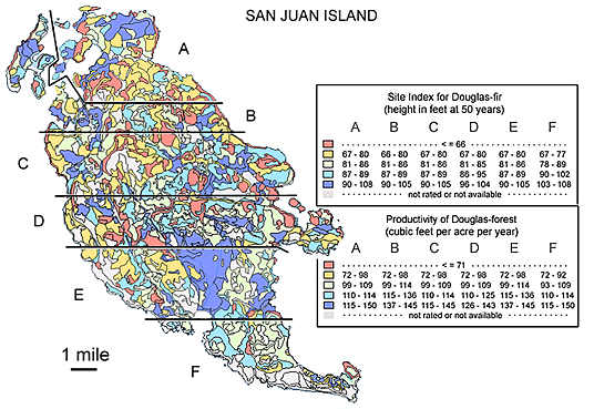
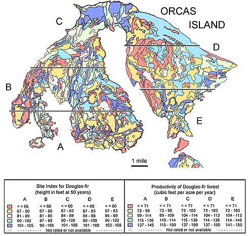
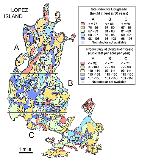
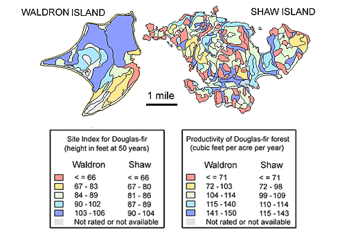
In June of 2009 the Natural Resources Conservation Service of USDA posted its new online soil survey for San Juan County (see http://websoilsurvey.nrcs.usda.gov). It radically updates the 50-year-old, printed Soil Survey of 1962 by establishing new soil units, revising soil names, and attaching more detailed interpretions of soil properties, capababilities, and usage suitabilities. Because it exists strictly online and is many-layered, however, the Web Soil Survey is somewhat awkward to access and use (see Appendix at the end of this page for a guide into the Web Soil Survey for its forest information). While a small geographic area is not hard to analyze, it is considerably more difficult to acquire a broader perspective of larger landscapes, such as entire islands in San Juan County. The custom-made map images of the major individual islands, shown below, overcome this limitation. In the Web Soil Survey forest productivity for a selected tree species is expressed by two measures:
The island-wide maps shown below have been custom-made for the present webpage.They display site Indices and productivities across San Juan, Orcas, Lopez, Shaw and Waldron Islands and have been pieced together from smaller segments because the online display is limited to areas of less than 10,000 acres. Unfortunately, the legend accompanying each segment is unique due to the algorithm that determines color codes and data ranges. |
||||
    |
||||
|
|
||||