| |
|
INTRODUCTION
Yellow Island, San Juan County,
WA, is currently owned by The Nature Conservancy (TNC), who actively
manages its vegetative land cover through restoration plantings,
plant removal, and occasional prescribed burning in order to
favor some species over others. In part, TNC's management efforts
are informed by an understanding of the conditions and processes
that existed prior to Euro-American settlement in the archipelago.
It is well to recall that such non-native settlement of the San
Juans began in earnest only after the General Land Office survey
of 1874 (which omitted Yellow Island). Until the mid-1900s, settlement
impact on Yellow Island was indirect, namely by cessation of
native visitations. Present and historic conditions on Yellow
Island were systematically studied by Agee and Dunwiddie (1984).
They inventoried the plant communities, performed age analyses
on trees, and documented evidence of past fires based on fire
scars. Certain conclusions in that study about the sparseness
of the pre-settlement forest were corroborated by a lone 1909
photograph from McConnell Island.
Recently
three unpublished images of Yellow Island, all dated 1895, were
discovered and retrieved from the National Archives. They include
a detailed land-cover map called a T-sheet and two associated
photographs, which together constitute the earliest direct documentation
of the island's large vegetation. These new images now assist
in the on-going efforts to document and understand the vegetation
dynamics on Yellow Island.
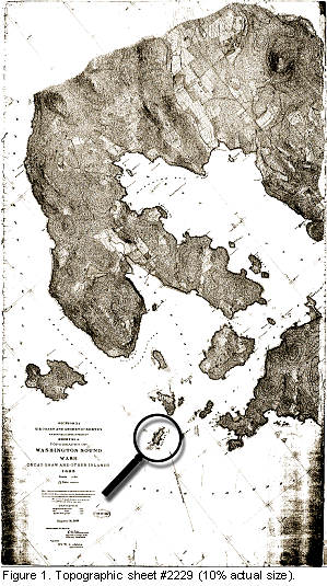
TOPOGRAPHIC SHEET #2229
T-2229 is one of fifteen manuscript
topographic sheets from 1888-1897 covering all of the San Juan
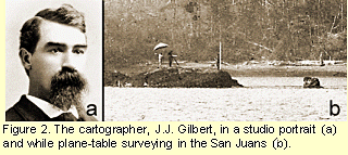
Islands (Fig. 1). They were prepared by J.J. Gilbert of the U.S.
Coast and Geodetic Survey, based on plane-table surveying technology
(Fig. 2). These exquisitely detailed documents represent the
earliest systematic documentation of the topography, land-cover,
and cultural features of the San Juans. Yellow Island appears
on T-sheet #2229, which was drafted in 1895 (USC&GS, 1895a)
(Fig. 3); the N-S axis is tilted 40° in order to fit the
area of coverage onto a sheet of tracing fabric measuring 2.7
by 4.8 ft.
T-sheets
for the San Juans were never published or circulated, so they
are little known today and their rich historic content has remained
unexamined. Steps to gain broader accessibility began in 2000
when the original T-sheets of the San Juans were photocopied
at full scale at the National Archives and Records Administration
(NARA II) in College Park, MD. The retrieved hardcopies were
then electronically scanned at 400 ppi and eventually posted
on the World Wide Web (WSU, 2002). On the full-size T-sheet #2229
(Fig. 3) the 1800-ft long axis of Yellow Island measures
about
2.25 in, and numerous topographical
features are indicated. The island's intertidal character is
depicted as rocky and sandy; and the distribution of offshore
kelp beds is also indicated. Inland relief is marked by topographic
lines at 20-ft intervals.At the island's highest point (about
60 ft) a dotted triangle indicates a triangulation station used
in the survey; it is identified as Signal Goose. Another
triangulation point at the NE point is not marked but is identified
as Signal Yellow (Fig. 4). At such triangulation points
braced poles were erected and typically 2-in holes were bored
in the rock as lasting locators; the surveying crew likely passed
some hours at these locations to make plane-table triangulations
and to record and render observations. Signals Goose and
Yellow would have afforded reasonable views of most of
the vegetation on the island in 1895.
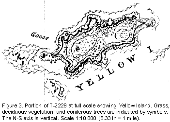
In Figure 3, vegetative land cover is depicted
by standard cartographic symbols: splays of upright ticks for
grass, C-shaped marks for deciduous vegetation (usually meaning
trees or large shrubs), and 5-lined stars for coniferous trees.
These hand-drawn symbols may signify individual trees or clusters
of such vegetation. Most of the ~23 symbols for conifers form
an array coursing from SSW to NNE across the middle of the island;
a cluster of three stars is located at the NE point and single
stars are located near the western point and just north of Signal
Goose. Most of the symbols for deciduous trees are scattered
over the western half of the island.
PHOTOGRAPHS
Along with his surveying activity
that produced the T-sheets, J.J. Gilbert also prepared
hand-written narrative reports with each T-sheet, and some of
those included landscape photographs or drawings. Two photographic
images of Yellow Island printed by a brown bromide-process were
pasted into the Descriptive Report for T-2229 (USC&GS,1895b).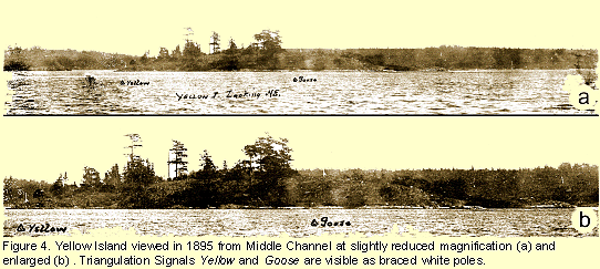
At
NARA II in May, 2002, the original prints were electronically
scanned at 300 ppi in black and white; the versions presented
here have been digitally enhanced and sepia-tinted. The photographic
negatives have not been located.
The view point of one scene (Fig.
4) is from the surveyors' boat in Middle Channel between San
Juan and Yellow Islands. A note indicates that the view is to
the NE, but it is more likely ESE, in which case Shaw Island
is the landmass in the background. The view point of the second
photograph (Fig. 5a,b) is from Neck Point, Shaw Island, nearly
a mile from Yellow Island, and is oriented WNW; San Juan Island
and other marked islands lie in the background; it has been rephotographed
(Fig. 5c and d).
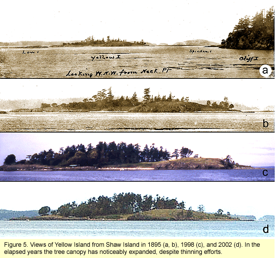 The two 7-inch
wide photographic prints included with the narrative report for
Yellow Island in the Descriptive Report for T-2229 are reproduced
at slight reductions in Figures 4a and 5a. Signals Yellow
and Goose are clearly indicated by braced white poles
in Figure 4; Signal Yellow is barely discernible on the
right in Figure 5. Image quality is sufficient, especially in
the enlargements, to reveal that ~23 coniferous trees occupied
the island in 1895; most were modest in stature, four or five
were quite tall, and one was a tall snag. Shrubs and small trees
are also indicated but cannot be clearly identified. A brief
text entry (below) by J.J. Gilbert in Descriptive Report T-2229
supports impressions of the island's vegetation gained from the
photographs and T-sheet: The two 7-inch
wide photographic prints included with the narrative report for
Yellow Island in the Descriptive Report for T-2229 are reproduced
at slight reductions in Figures 4a and 5a. Signals Yellow
and Goose are clearly indicated by braced white poles
in Figure 4; Signal Yellow is barely discernible on the
right in Figure 5. Image quality is sufficient, especially in
the enlargements, to reveal that ~23 coniferous trees occupied
the island in 1895; most were modest in stature, four or five
were quite tall, and one was a tall snag. Shrubs and small trees
are also indicated but cannot be clearly identified. A brief
text entry (below) by J.J. Gilbert in Descriptive Report T-2229
supports impressions of the island's vegetation gained from the
photographs and T-sheet:
"Yellow Island.the
westernmost of the Wasp Islands, and locally known as Goose Island,
is rocky and rather
sparcely (sic) covered with willow and other brush and
a few scattering fir trees.
Off the west end are several reefs, mostly covered at low tide.
There is anchorage for a launch or other small craft on the north
side of the spit at west end of island." (USC&GS, 1895b, p. 9; emphasis added).
DISCUSSION
According to J.J. Gilbert's narrative
description, the associated photographs, and the cartographic
details of T-sheet #2229, the large vegetation of Yellow Island
in 1895 was sparse, composed of both deciduous and coniferous
forms, and located primarily near the center of the island. The
recently rephotographed profile of the island from Shaw Island
(Fig. 5c) illustrates some of the changes in large vegetation
that have occurred over a span of 107 years. Compared to 1895,
the average forest canopy (or "skyline") is now taller,
the forest zone is broader and denser in terms of foliage and
number of trees, and large spherical masses of opaque foliage
indicative of deciduous forms are prominent today, at least facing
the SE. The tallest trees in 1895 and 2002 are about the same
height, but the number of tall trees is now greater. The tall
snag a century ago and the solitary tall tree at the right in
Figure 5b are no longer present.
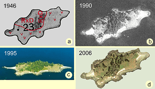
Figure 6. Aerial photographs of Yellow
Island from 1946 to 2006. Images are sized to correspond
to Figure 3. N-S axis is vertical in (a), (b), and (d).
Further
insights into vegetation changes might benefit from comparisons
with additional images, for example, from times between 1895
and the present. Figure 6a depicts vegetation on Yellow Island
in 1946, which is a published aerial photograph in the soil survey
for San Juan County (USDA, 1962); this published image is admittedly
inferior in quality and somewhat obscured by overlays of soil
polygons, their designations, and V-shaped symbols signifying
rock outcrops. Dark amorphous images of major vegetation
are clearly confined to a swath across the island's middle. Efforts
to obtain superior prints of this photograph or to locate its
negative were unrewarded.
Fairly recent aerial photographs,
such as from the 1990 WDNR series (Fig. 6b) or the 1995 WDOE
series (Fig. 6c), more clearly reveal the present-day distribution
of vegetation. According to these images, large vegetation
meaning trees and shrubs have expanded laterally from the
narrower central swath seen in 1946. Quite recently (Fig. 6d),
however, from the online source Digital Globe (see tagzania.com
website), the zone occupied by large trees and shrubs has been
reduced by aggressive management, that is tree removal.
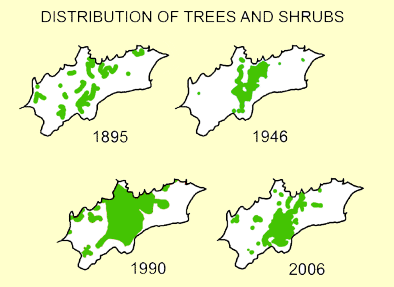
Figure 7. Summary of zones occupied by
major trees and shrubs from 1895 to 2006.
A
rough summary of vegetation changes from 1895 to the present
is shown graphically in Figure 7, which is derived from data
in Figures 3, and 6a-c. The sequence indicates that up to 1990
the area of forest coverage progressively doubled during each
50-year period by encroaching laterally into grassy meadows.
These changes concur with the findings reported by Agee and Dunwiddie
(1984). Since 1990, however, thanks to TNC's active management
and removal of many trees, the zone occupied by trees has been
reduced to the condition that existed in about 1946. Removal
of even more trees may be required to restore the vegetation
condition reported in the 1895 images, which are here reported
for the first time.
REFERENCES
Agee, J.K. and P.W. Dunwiddie (1984). Recent forest development
on Yellow Island, San Juan County, WA. Can. J. Bot. 65: 2074-2080.
Digital Globe (2006). Online
URL: www. tagzania.com.
U.S. Coast and Geodetic Survey (1895a). Topographic Sheet No.
2229: Topography of Washington Sound, Wash. Orcas and Other Islands.
Section XI, Sheet No. 8 (1:10,000).
National Archives and Records Administration, (Cartographic Division,
Record Group 23), College Park, MD.
U.S. Coast and Geodetic Survey (1895b). Descriptive Report, Sheet
No. 2229. Topography of Washington Sound (by J.J. Gilbert). National
Archives and Records Administration, (Cartographic Division,
Record Group 23), College Park, MD. 18 pp; 14 photographs.
U.S. Geological Service (1941). Aerial photographs of San Juan
County, Washington (B&W; 1:34,000). (Symbol S, Rolls 1-5,
Cans #2985-2989). National Archives and Records Administration,
(Cartographic Division, Record Group 23), College Park, MD.
U.S. Department of Agriculture (1962). Soil Survey: San Juan
County, Washington (by F.E. Schlots, et al.), 73 pp.
Washington State University (2002). See online URL: www.wsulibs.wsu.edu/holland/masc,
select "Digital Collection," under "Northwest
History" select "Early Washington Maps," and finally
select
"Historic Maps of San Juan Islands (1887-1895)." By
selecting an individual map from the index a thumbnail image
will appear. Click on the thumbnail to view an intermediate-size
image; to enlarge the image further, first scroll down to the
bottom of the thunbnail and click "View Map Image"
in order to zoom in for a closer look. Activate the zooming function
by clicking on the specific area of map that interests you, but
take note at this stage whichever detail of the intermediate-size
map is clicked will be the portion that is zoomed. Navigating
laterally beyond the zoomed image is not possible, so to move
to another zoomed area one must first backtrack to the intermediate
image and activate another detail. In 2003 the same T-sheets
(including their Descriptive Reports) were posted on another
URL: http://riverhistory.ess.washington.edu/tsheets/framedex.htm
; when this page opens select a red button for the desired location,
select "Original Scanned Image," and proceed as above
to zoom into a selected portion of the image.
Washington Department of Ecology (1995). Shoreline Aerial Photographs:
SNJ1362, 9/23/1995, 12:14:00 PM, Yellow Island (color; oblique).
On-line URL: apps.ecy.wa.gov/shorephotos/maps.htm
Washington Department of Natural Resources (1990). Aerial photographs:
San Juan County, Washington (B&W). Electronic files.
Washington Department of Natural Resources (2002) See online
URL: www.wa.gov/dnr/htdocs/ adm/comm/nr02-54.htm
|
|
|